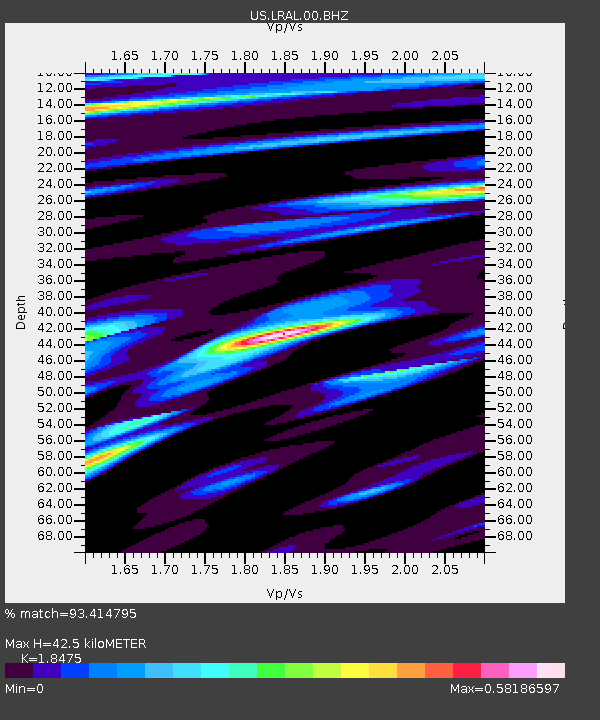
LRAL Lakeview Retreat, Alabama, USA - Earthquake Result Viewer

Earthquake location: Andreanof Islands, Aleutian Is.
Earthquake latitude/longitude: 51.6/-178.3
Earthquake time(UTC): 2012/09/26 (270) 23:39:55 GMT
Earthquake Depth: 16 km
Earthquake Magnitude: 6.3 MB, 6.5 MS, 6.4 MW, 6.4 MW
Earthquake Catalog/Contributor: WHDF/NEIC
Network: US United States National Seismic Network
Station: LRAL Lakeview Retreat, Alabama, USA
Lat/Lon: 33.03 N/87.00 W
Elevation: 130 m
Distance: 65.7 deg
Az: 67.182 deg
Baz: 316.802 deg
Ray Param: 0.058115292
Estimated Moho Depth: 42.5 km
Estimated Crust Vp/Vs: 1.85
Assumed Crust Vp: 6.565 km/s
Estimated Crust Vs: 3.553 km/s
Estimated Crust Poisson's Ratio: 0.29
Radial Match: 93.414795 %
Radial Bump: 400
Transverse Match: 80.72814 %
Transverse Bump: 400
SOD ConfigId: 558545
Insert Time: 2013-09-17 19:26:34.815 +0000
GWidth: 2.5
Max Bumps: 400
Tol: 0.001

Signal To Noise

ChannelStoNSTALTA
US:LRAL:00:BHZ:20120926T23:50:07.325027Z23.6863211.7317972E-67.311381E-8
US:LRAL:00:BH1:20120926T23:50:07.325027Z6.4393464.4700283E-76.941743E-8
US:LRAL:00:BH2:20120926T23:50:07.325027Z4.69289353.6740428E-77.8289496E-8
Arrivals
Ps5.7 SECOND
PpPs18 SECOND
PsPs/PpSs23 SECOND