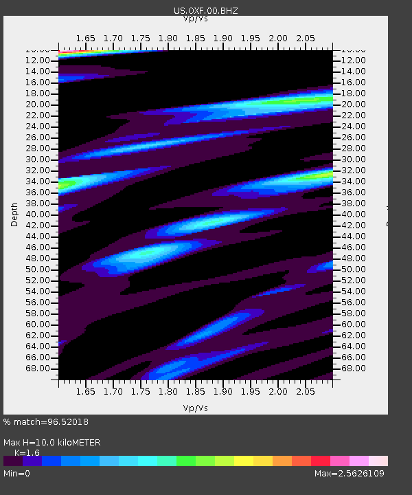
OXF Oxford, Mississippi, USA - Earthquake Result Viewer
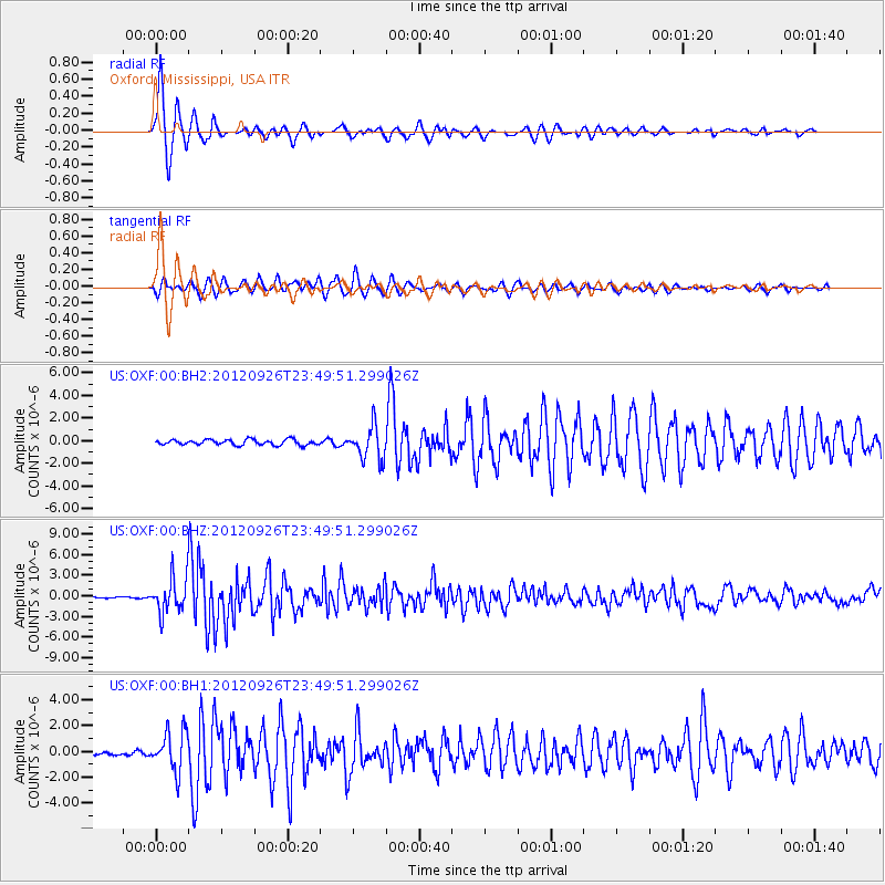
Earthquake location: Andreanof Islands, Aleutian Is.
Earthquake latitude/longitude: 51.6/-178.3
Earthquake time(UTC): 2012/09/26 (270) 23:39:55 GMT
Earthquake Depth: 16 km
Earthquake Magnitude: 6.3 MB, 6.5 MS, 6.4 MW, 6.4 MW
Earthquake Catalog/Contributor: WHDF/NEIC
Network: US United States National Seismic Network
Station: OXF Oxford, Mississippi, USA
Lat/Lon: 34.51 N/89.41 W
Elevation: 101 m
Distance: 63.2 deg
Az: 67.66 deg
Baz: 315.675 deg
Ray Param: 0.059715614
Estimated Moho Depth: 10.0 km
Estimated Crust Vp/Vs: 1.60
Assumed Crust Vp: 6.38 km/s
Estimated Crust Vs: 3.988 km/s
Estimated Crust Poisson's Ratio: 0.18
Radial Match: 96.52018 %
Radial Bump: 320
Transverse Match: 91.65179 %
Transverse Bump: 400
SOD ConfigId: 558545
Insert Time: 2013-09-17 19:27:16.844 +0000
GWidth: 2.5
Max Bumps: 400
Tol: 0.001

Signal To Noise

ChannelStoNSTALTA
US:OXF:00:BHZ:20120926T23:49:51.299026Z29.0342792.5571558E-68.8073676E-8
US:OXF:00:BH1:20120926T23:49:51.299026Z8.4153791.5280616E-61.8157965E-7
US:OXF:00:BH2:20120926T23:49:51.299026Z6.09800961.437107E-62.3566821E-7
Arrivals
Ps1.0 SECOND
PpPs3.9 SECOND
PsPs/PpSs4.9 SECOND