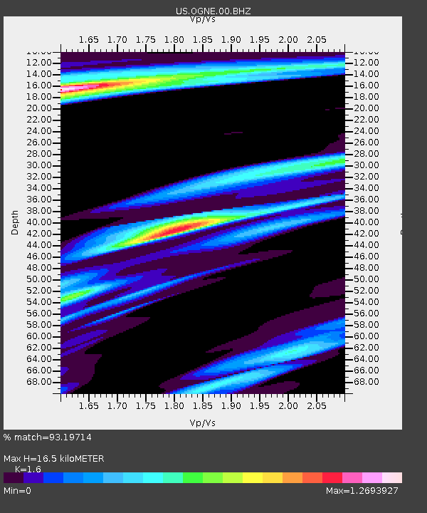
OGNE Ogallala, Nebraska, USA - Earthquake Result Viewer
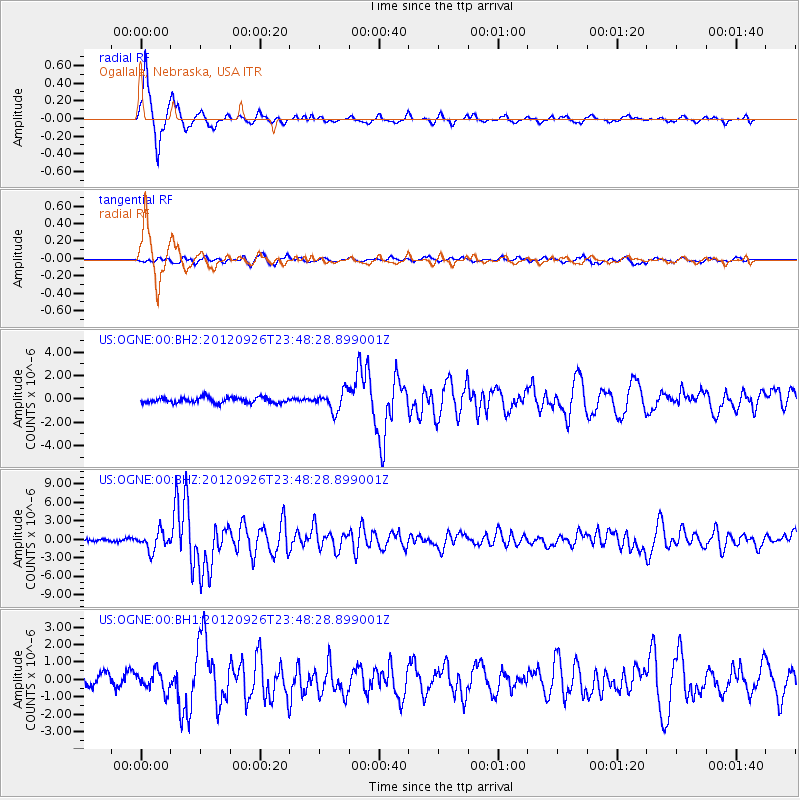
Earthquake location: Andreanof Islands, Aleutian Is.
Earthquake latitude/longitude: 51.6/-178.3
Earthquake time(UTC): 2012/09/26 (270) 23:39:55 GMT
Earthquake Depth: 16 km
Earthquake Magnitude: 6.3 MB, 6.5 MS, 6.4 MW, 6.4 MW
Earthquake Catalog/Contributor: WHDF/NEIC
Network: US United States National Seismic Network
Station: OGNE Ogallala, Nebraska, USA
Lat/Lon: 40.95 N/102.03 W
Elevation: 0.0 m
Distance: 51.5 deg
Az: 70.081 deg
Baz: 309.263 deg
Ray Param: 0.06735682
Estimated Moho Depth: 16.5 km
Estimated Crust Vp/Vs: 1.60
Assumed Crust Vp: 6.483 km/s
Estimated Crust Vs: 4.052 km/s
Estimated Crust Poisson's Ratio: 0.18
Radial Match: 93.19714 %
Radial Bump: 218
Transverse Match: 64.08349 %
Transverse Bump: 400
SOD ConfigId: 558545
Insert Time: 2013-09-17 19:27:17.344 +0000
GWidth: 2.5
Max Bumps: 400
Tol: 0.001

Signal To Noise

ChannelStoNSTALTA
US:OGNE:00:BHZ:20120926T23:48:28.899001Z6.93876551.4639627E-62.1098315E-7
US:OGNE:00:BH1:20120926T23:48:28.899001Z1.55640115.5483787E-73.564877E-7
US:OGNE:00:BH2:20120926T23:48:28.899001Z3.5159658.282207E-72.3556001E-7
Arrivals
Ps1.6 SECOND
PpPs6.2 SECOND
PsPs/PpSs7.8 SECOND