SDCO Great Sand Dunes National Park, Colorado, USA - Earthquake Result Viewer
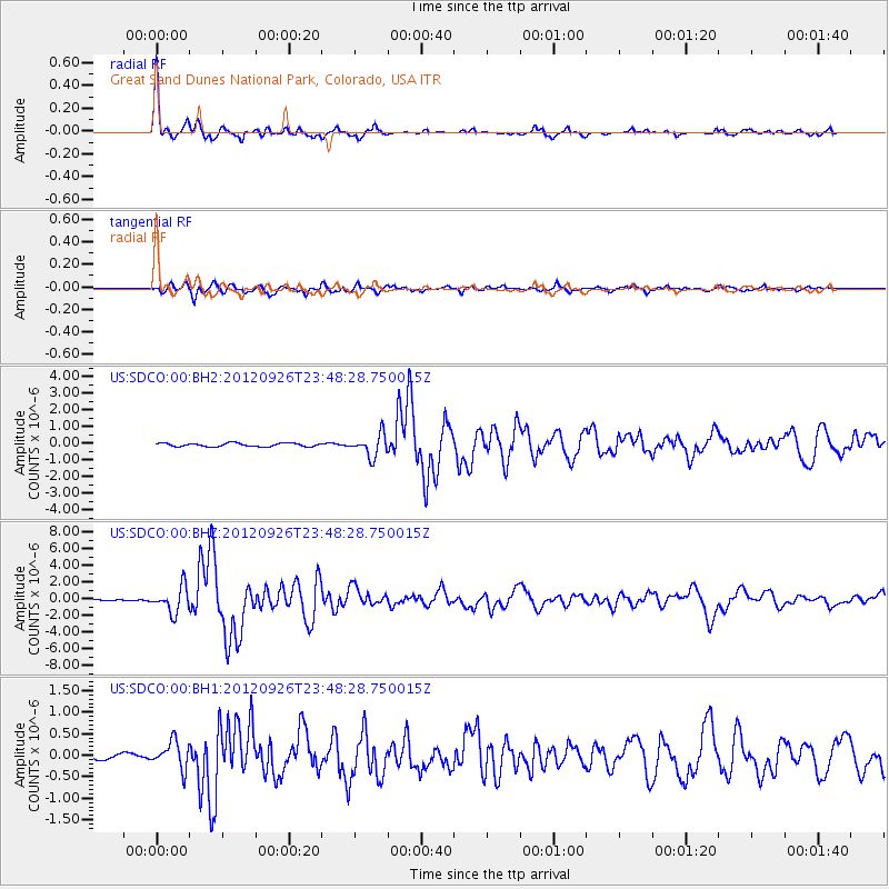
Earthquake location: Andreanof Islands, Aleutian Is.
Earthquake latitude/longitude: 51.6/-178.3
Earthquake time(UTC): 2012/09/26 (270) 23:39:55 GMT
Earthquake Depth: 16 km
Earthquake Magnitude: 6.3 MB, 6.5 MS, 6.4 MW, 6.4 MW
Earthquake Catalog/Contributor: WHDF/NEIC
Network: US United States National Seismic Network
Station: SDCO Great Sand Dunes National Park, Colorado, USA
Lat/Lon: 37.75 N/105.50 W
Elevation: 2569 m
Distance: 51.5 deg
Az: 75.418 deg
Baz: 310.396 deg
Ray Param: 0.06736986
Estimated Moho Depth: 37.0 km
Estimated Crust Vp/Vs: 2.01
Assumed Crust Vp: 6.316 km/s
Estimated Crust Vs: 3.142 km/s
Estimated Crust Poisson's Ratio: 0.34
Radial Match: 96.6974 %
Radial Bump: 305
Transverse Match: 91.00135 %
Transverse Bump: 400
SOD ConfigId: 558545
Insert Time: 2013-09-17 19:27:30.708 +0000
GWidth: 2.5
Max Bumps: 400
Tol: 0.001

Signal To Noise

ChannelStoNSTALTA
US:SDCO:00:BHZ:20120926T23:48:28.750015Z18.704151.5393445E-68.229962E-8
US:SDCO:00:BH1:20120926T23:48:28.750015Z3.8185253.1597037E-78.274671E-8
US:SDCO:00:BH2:20120926T23:48:28.750015Z6.52424536.7263903E-71.0309837E-7
Arrivals
Ps6.2 SECOND
PpPs17 SECOND
PsPs/PpSs23 SECOND