You are here: Home > Network List > IU - Global Seismograph Network (GSN - IRIS/USGS) Stations List
> Station POHA Pohakuloa, Hawaii, USA > Earthquake Result Viewer
POHA Pohakuloa, Hawaii, USA - Earthquake Result Viewer
*The percent match for this event was below the threshold and hence no stack was calculated.
| Earthquake location: |
Solomon Islands |
| Earthquake latitude/longitude: |
-8.8/157.5 |
| Earthquake time(UTC): |
2012/09/27 (271) 23:53:49 GMT |
| Earthquake Depth: |
10 km |
| Earthquake Magnitude: |
5.6 MB, 5.4 MS, 5.8 MW, 6.0 MW |
| Earthquake Catalog/Contributor: |
WHDF/NEIC |
|
| Network: |
IU Global Seismograph Network (GSN - IRIS/USGS) |
| Station: |
POHA Pohakuloa, Hawaii, USA |
| Lat/Lon: |
19.76 N/155.53 W |
| Elevation: |
1990 m |
|
| Distance: |
54.3 deg |
| Az: |
58.023 deg |
| Baz: |
242.883 deg |
| Ray Param: |
$rayparam |
*The percent match for this event was below the threshold and hence was not used in the summary stack. |
|
| Radial Match: |
59.575645 % |
| Radial Bump: |
400 |
| Transverse Match: |
53.755936 % |
| Transverse Bump: |
400 |
| SOD ConfigId: |
558545 |
| Insert Time: |
2013-09-17 19:29:48.068 +0000 |
| GWidth: |
2.5 |
| Max Bumps: |
400 |
| Tol: |
0.001 |
|
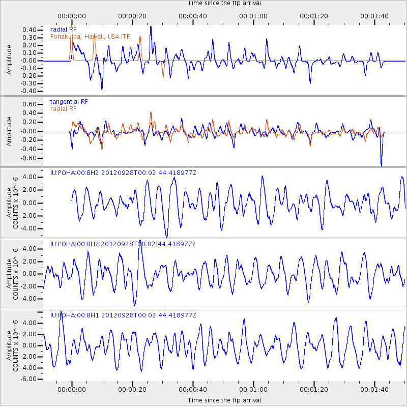
Signal To Noise
| Channel | StoN | STA | LTA |
| IU:POHA:00:BHZ:20120928T00:02:44.418977Z | 1.3067498 | 1.8938209E-6 | 1.4492605E-6 |
| IU:POHA:00:BH1:20120928T00:02:44.418977Z | 0.9143909 | 1.662447E-6 | 1.8180922E-6 |
| IU:POHA:00:BH2:20120928T00:02:44.418977Z | 2.1443517 | 3.135497E-6 | 1.4622121E-6 |
| Arrivals |
| Ps | |
| PpPs | |
| PsPs/PpSs | |


