You are here: Home > Network List > US - United States National Seismic Network Stations List
> Station ERPA Erie, Pennsylvania, USA > Earthquake Result Viewer
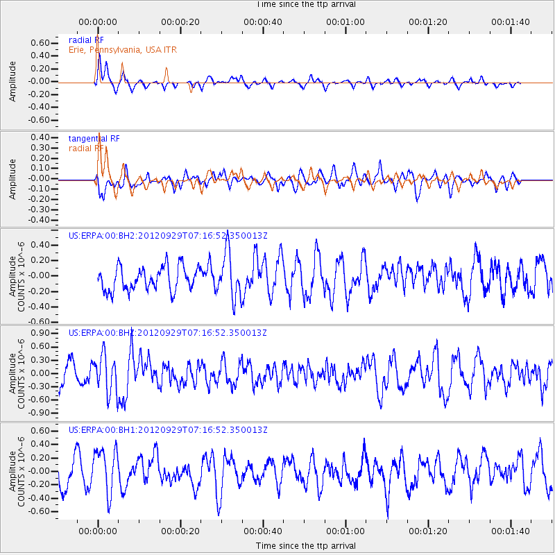
ERPA Erie, Pennsylvania, USA - Earthquake Result Viewer
*The percent match for this event was below the threshold and hence no stack was calculated.
| Earthquake location: |
Near Coast Of Guerrero, Mexico |
| Earthquake latitude/longitude: |
16.3/-98.4 |
| Earthquake time(UTC): |
2012/09/29 (273) 07:11:12 GMT |
| Earthquake Depth: |
12 km |
| Earthquake Magnitude: |
5.5 MW, 4.9 MS, 5.3 MB, 5.4 MW |
| Earthquake Catalog/Contributor: |
WHDF/NEIC |
|
| Network: |
US United States National Seismic Network |
| Station: |
ERPA Erie, Pennsylvania, USA |
| Lat/Lon: |
42.12 N/79.99 W |
| Elevation: |
306 m |
|
| Distance: |
30.2 deg |
| Az: |
27.844 deg |
| Baz: |
217.074 deg |
| Ray Param: |
$rayparam |
*The percent match for this event was below the threshold and hence was not used in the summary stack. |
|
| Radial Match: |
58.144623 % |
| Radial Bump: |
400 |
| Transverse Match: |
35.776363 % |
| Transverse Bump: |
400 |
| SOD ConfigId: |
558545 |
| Insert Time: |
2013-09-17 19:33:22.004 +0000 |
| GWidth: |
2.5 |
| Max Bumps: |
400 |
| Tol: |
0.001 |
|
Signal To Noise
| Channel | StoN | STA | LTA |
| US:ERPA:00:BHZ:20120929T07:16:52.350013Z | 1.9899179 | 4.402638E-7 | 2.2124722E-7 |
| US:ERPA:00:BH1:20120929T07:16:52.350013Z | 1.5076032 | 3.5753752E-7 | 2.3715627E-7 |
| US:ERPA:00:BH2:20120929T07:16:52.350013Z | 1.978984 | 3.0121873E-7 | 1.5220877E-7 |
| Arrivals |
| Ps | |
| PpPs | |
| PsPs/PpSs | |


