You are here: Home > Network List > US - United States National Seismic Network Stations List
> Station AMTX Amarillo, Texas, USA > Earthquake Result Viewer
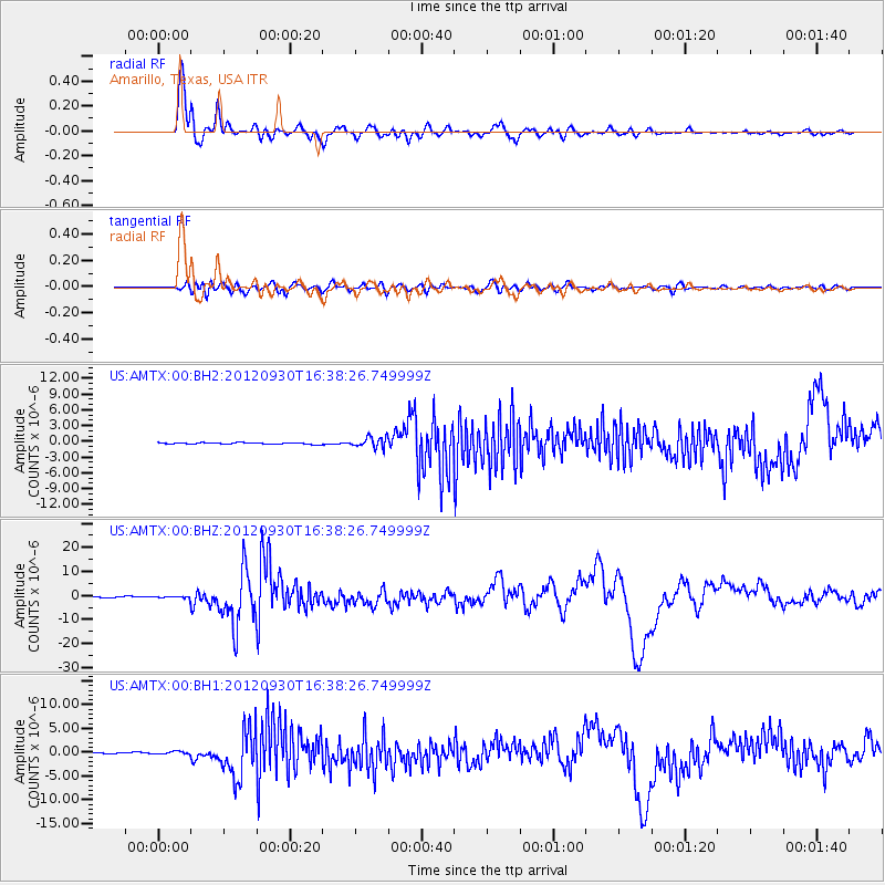
AMTX Amarillo, Texas, USA - Earthquake Result Viewer
*The percent match for this event was below the threshold and hence no stack was calculated.
| Earthquake location: |
Colombia |
| Earthquake latitude/longitude: |
1.9/-76.4 |
| Earthquake time(UTC): |
2012/09/30 (274) 16:31:35 GMT |
| Earthquake Depth: |
170 km |
| Earthquake Magnitude: |
7.0 MB, 7.3 MW, 7.2 MW |
| Earthquake Catalog/Contributor: |
WHDF/NEIC |
|
| Network: |
US United States National Seismic Network |
| Station: |
AMTX Amarillo, Texas, USA |
| Lat/Lon: |
34.53 N/101.41 W |
| Elevation: |
1010 m |
|
| Distance: |
40.0 deg |
| Az: |
327.035 deg |
| Baz: |
138.799 deg |
| Ray Param: |
$rayparam |
*The percent match for this event was below the threshold and hence was not used in the summary stack. |
|
| Radial Match: |
95.90406 % |
| Radial Bump: |
400 |
| Transverse Match: |
79.293304 % |
| Transverse Bump: |
400 |
| SOD ConfigId: |
558545 |
| Insert Time: |
2013-09-17 19:36:27.996 +0000 |
| GWidth: |
2.5 |
| Max Bumps: |
400 |
| Tol: |
0.001 |
|
Signal To Noise
| Channel | StoN | STA | LTA |
| US:AMTX:00:BHZ:20120930T16:38:26.749999Z | 2.4705195 | 4.759618E-7 | 1.9265656E-7 |
| US:AMTX:00:BH1:20120930T16:38:26.749999Z | 2.4875448 | 3.0222262E-7 | 1.2149434E-7 |
| US:AMTX:00:BH2:20120930T16:38:26.749999Z | 1.9332367 | 2.2506373E-7 | 1.1641809E-7 |
| Arrivals |
| Ps | |
| PpPs | |
| PsPs/PpSs | |


