You are here: Home > Network List > US - United States National Seismic Network Stations List
> Station SDCO Great Sand Dunes National Park, Colorado, USA > Earthquake Result Viewer
SDCO Great Sand Dunes National Park, Colorado, USA - Earthquake Result Viewer
| Earthquake location: |
Colombia |
| Earthquake latitude/longitude: |
1.9/-76.4 |
| Earthquake time(UTC): |
2012/09/30 (274) 16:31:35 GMT |
| Earthquake Depth: |
170 km |
| Earthquake Magnitude: |
7.0 MB, 7.3 MW, 7.2 MW |
| Earthquake Catalog/Contributor: |
WHDF/NEIC |
|
| Network: |
US United States National Seismic Network |
| Station: |
SDCO Great Sand Dunes National Park, Colorado, USA |
| Lat/Lon: |
37.75 N/105.50 W |
| Elevation: |
2569 m |
|
| Distance: |
44.6 deg |
| Az: |
326.631 deg |
| Baz: |
136.095 deg |
| Ray Param: |
0.07119046 |
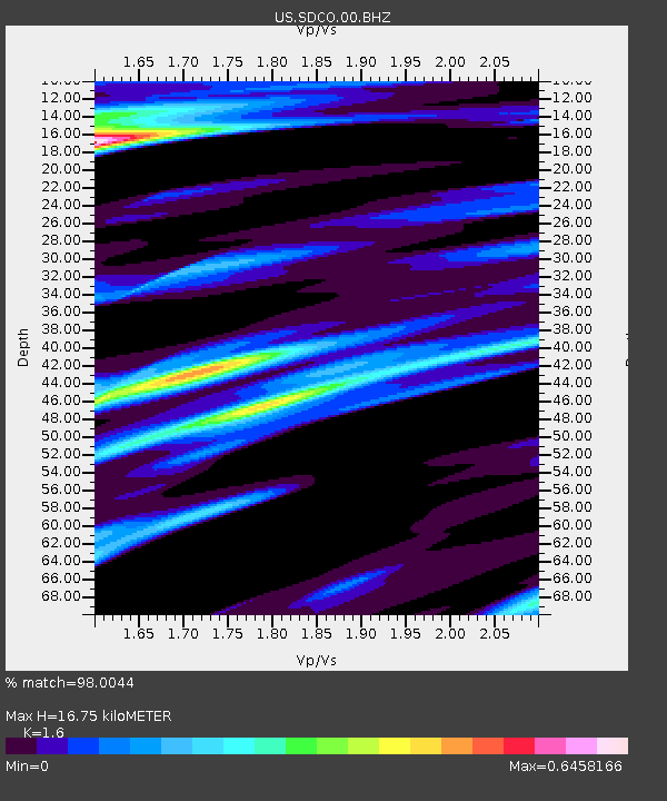
| Estimated Moho Depth: |
16.75 km |
| Estimated Crust Vp/Vs: |
1.60 |
| Assumed Crust Vp: |
6.316 km/s |
| Estimated Crust Vs: |
3.947 km/s |
| Estimated Crust Poisson's Ratio: |
0.18 |
|
| Radial Match: |
98.0044 % |
| Radial Bump: |
333 |
| Transverse Match: |
91.866844 % |
| Transverse Bump: |
400 |
| SOD ConfigId: |
558545 |
| Insert Time: |
2013-09-17 19:39:12.426 +0000 |
| GWidth: |
2.5 |
| Max Bumps: |
400 |
| Tol: |
0.001 |
|

Signal To Noise
| Channel | StoN | STA | LTA |
| US:SDCO:00:BHZ:20120930T16:39:00.473998Z | 26.56695 | 3.634522E-6 | 1.3680615E-7 |
| US:SDCO:00:BH1:20120930T16:39:00.473998Z | 9.367752 | 8.321796E-7 | 8.8834504E-8 |
| US:SDCO:00:BH2:20120930T16:39:00.473998Z | 5.80502 | 1.2799826E-6 | 2.204958E-7 |
| Arrivals |
| Ps | 1.7 SECOND |
| PpPs | 6.4 SECOND |
| PsPs/PpSs | 8.1 SECOND |


