You are here: Home > Network List > US - United States National Seismic Network Stations List
> Station TZTN Tazewell, Tennessee, USA > Earthquake Result Viewer
TZTN Tazewell, Tennessee, USA - Earthquake Result Viewer

| Earthquake location: |
Colombia |
| Earthquake latitude/longitude: |
1.9/-76.4 |
| Earthquake time(UTC): |
2012/09/30 (274) 16:31:35 GMT |
| Earthquake Depth: |
170 km |
| Earthquake Magnitude: |
7.0 MB, 7.3 MW, 7.2 MW |
| Earthquake Catalog/Contributor: |
WHDF/NEIC |
|
| Network: |
US United States National Seismic Network |
| Station: |
TZTN Tazewell, Tennessee, USA |
| Lat/Lon: |
36.54 N/83.55 W |
| Elevation: |
394 m |
|
| Distance: |
35.1 deg |
| Az: |
349.903 deg |
| Baz: |
167.434 deg |
| Ray Param: |
0.07680765 |
| Estimated Moho Depth: |
21.5 km |
| Estimated Crust Vp/Vs: |
1.63 |
| Assumed Crust Vp: |
6.476 km/s |
| Estimated Crust Vs: |
3.979 km/s |
| Estimated Crust Poisson's Ratio: |
0.20 |
|
| Radial Match: |
87.12659 % |
| Radial Bump: |
400 |
| Transverse Match: |
96.1697 % |
| Transverse Bump: |
360 |
| SOD ConfigId: |
558545 |
| Insert Time: |
2013-09-17 19:39:19.582 +0000 |
| GWidth: |
2.5 |
| Max Bumps: |
400 |
| Tol: |
0.001 |
|
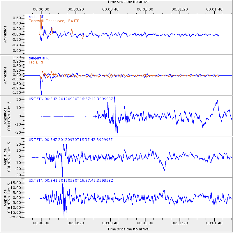
Signal To Noise
| Channel | StoN | STA | LTA |
| US:TZTN:00:BHZ:20120930T16:37:42.399993Z | 35.904396 | 2.8912016E-6 | 8.0525E-8 |
| US:TZTN:00:BH1:20120930T16:37:42.399993Z | 28.953375 | 1.9494164E-6 | 6.732951E-8 |
| US:TZTN:00:BH2:20120930T16:37:42.399993Z | 20.982042 | 2.1422152E-6 | 1.0209755E-7 |
| Arrivals |
| Ps | 2.3 SECOND |
| PpPs | 8.0 SECOND |
| PsPs/PpSs | 10 SECOND |


