You are here: Home > Network List > US - United States National Seismic Network Stations List
> Station WRAK Wrangell Island, Southeastern Alaska, Alaska, USA > Earthquake Result Viewer
WRAK Wrangell Island, Southeastern Alaska, Alaska, USA - Earthquake Result Viewer
| Earthquake location: |
Colombia |
| Earthquake latitude/longitude: |
1.9/-76.4 |
| Earthquake time(UTC): |
2012/09/30 (274) 16:31:35 GMT |
| Earthquake Depth: |
170 km |
| Earthquake Magnitude: |
7.0 MB, 7.3 MW, 7.2 MW |
| Earthquake Catalog/Contributor: |
WHDF/NEIC |
|
| Network: |
US United States National Seismic Network |
| Station: |
WRAK Wrangell Island, Southeastern Alaska, Alaska, USA |
| Lat/Lon: |
56.42 N/132.35 W |
| Elevation: |
81 m |
|
| Distance: |
70.2 deg |
| Az: |
330.692 deg |
| Baz: |
118.31 deg |
| Ray Param: |
0.054665655 |
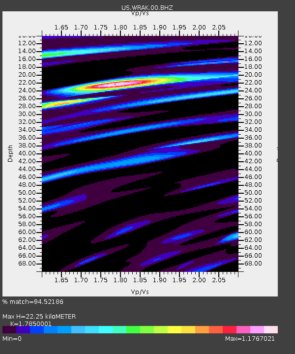
| Estimated Moho Depth: |
22.25 km |
| Estimated Crust Vp/Vs: |
1.79 |
| Assumed Crust Vp: |
6.597 km/s |
| Estimated Crust Vs: |
3.696 km/s |
| Estimated Crust Poisson's Ratio: |
0.27 |
|
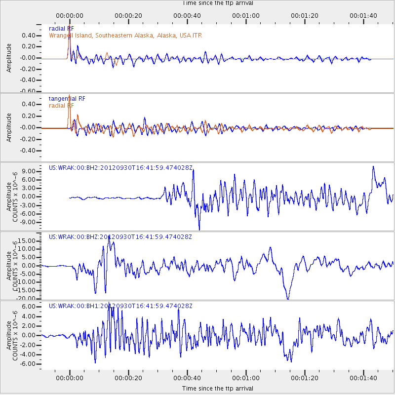
| Radial Match: |
94.52186 % |
| Radial Bump: |
400 |
| Transverse Match: |
84.874115 % |
| Transverse Bump: |
400 |
| SOD ConfigId: |
558545 |
| Insert Time: |
2013-09-17 19:39:36.861 +0000 |
| GWidth: |
2.5 |
| Max Bumps: |
400 |
| Tol: |
0.001 |
|
Signal To Noise
| Channel | StoN | STA | LTA |
| US:WRAK:00:BHZ:20120930T16:41:59.474028Z | 10.769122 | 2.6534842E-6 | 2.4639743E-7 |
| US:WRAK:00:BH1:20120930T16:41:59.474028Z | 4.6698904 | 8.524156E-7 | 1.825344E-7 |
| US:WRAK:00:BH2:20120930T16:41:59.474028Z | 6.0430336 | 1.3665002E-6 | 2.2612818E-7 |
| Arrivals |
| Ps | 2.8 SECOND |
| PpPs | 9.0 SECOND |
| PsPs/PpSs | 12 SECOND |


