You are here: Home > Network List > IU - Global Seismograph Network (GSN - IRIS/USGS) Stations List
> Station POHA Pohakuloa, Hawaii, USA > Earthquake Result Viewer
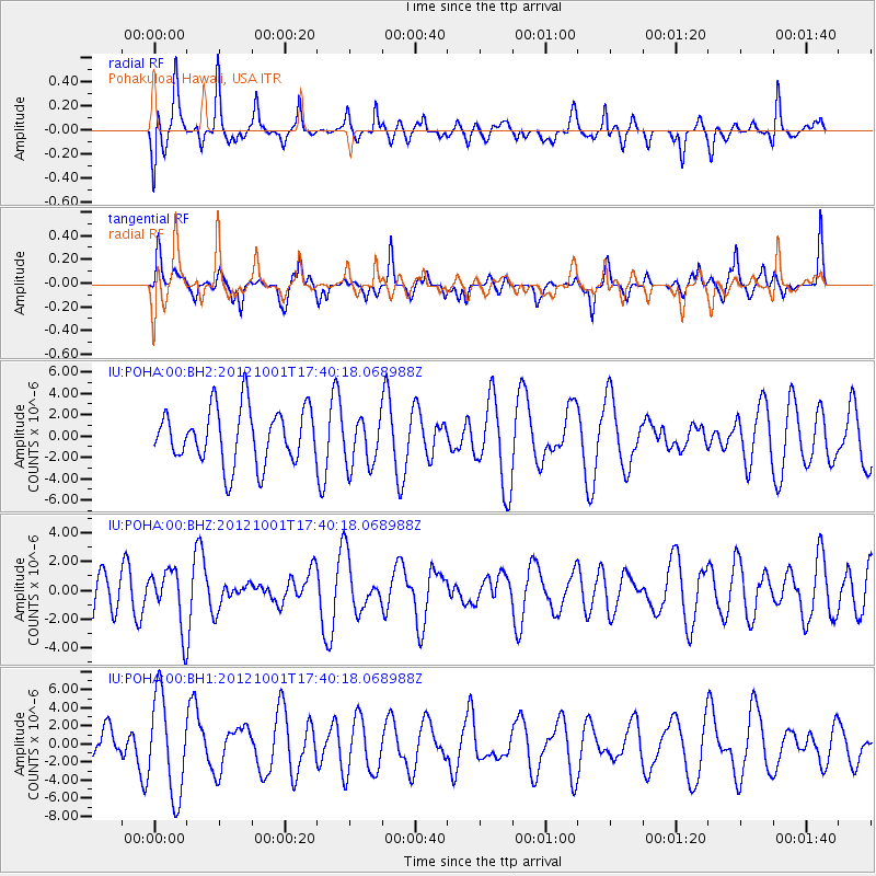
POHA Pohakuloa, Hawaii, USA - Earthquake Result Viewer
*The percent match for this event was below the threshold and hence no stack was calculated.
| Earthquake location: |
Off Coast Of Jalisco, Mexico |
| Earthquake latitude/longitude: |
18.6/-107.2 |
| Earthquake time(UTC): |
2012/10/01 (275) 17:32:28 GMT |
| Earthquake Depth: |
10 km |
| Earthquake Magnitude: |
5.5 MW |
| Earthquake Catalog/Contributor: |
NEIC PDE/NEIC PDE-W |
|
| Network: |
IU Global Seismograph Network (GSN - IRIS/USGS) |
| Station: |
POHA Pohakuloa, Hawaii, USA |
| Lat/Lon: |
19.76 N/155.53 W |
| Elevation: |
1990 m |
|
| Distance: |
45.6 deg |
| Az: |
279.692 deg |
| Baz: |
83.003 deg |
| Ray Param: |
$rayparam |
*The percent match for this event was below the threshold and hence was not used in the summary stack. |
|
| Radial Match: |
39.49906 % |
| Radial Bump: |
377 |
| Transverse Match: |
55.722015 % |
| Transverse Bump: |
352 |
| SOD ConfigId: |
558545 |
| Insert Time: |
2013-09-17 19:41:39.275 +0000 |
| GWidth: |
2.5 |
| Max Bumps: |
400 |
| Tol: |
0.001 |
|
Signal To Noise
| Channel | StoN | STA | LTA |
| IU:POHA:00:BHZ:20121001T17:40:18.068988Z | 0.9804387 | 1.9493057E-6 | 1.9881973E-6 |
| IU:POHA:00:BH1:20121001T17:40:18.068988Z | 2.2799356 | 5.410915E-6 | 2.3732755E-6 |
| IU:POHA:00:BH2:20121001T17:40:18.068988Z | 0.91069883 | 2.353535E-6 | 2.5843174E-6 |
| Arrivals |
| Ps | |
| PpPs | |
| PsPs/PpSs | |


