You are here: Home > Network List > IU - Global Seismograph Network (GSN - IRIS/USGS) Stations List
> Station PMG Port Moresby, New Guinea > Earthquake Result Viewer
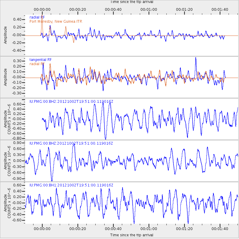
PMG Port Moresby, New Guinea - Earthquake Result Viewer
*The percent match for this event was below the threshold and hence no stack was calculated.
| Earthquake location: |
Balleny Islands Region |
| Earthquake latitude/longitude: |
-65.0/177.8 |
| Earthquake time(UTC): |
2012/10/02 (276) 19:41:29 GMT |
| Earthquake Depth: |
18 km |
| Earthquake Magnitude: |
5.6 MW, 5.5 MW |
| Earthquake Catalog/Contributor: |
NEIC PDE/NEIC PDE-W |
|
| Network: |
IU Global Seismograph Network (GSN - IRIS/USGS) |
| Station: |
PMG Port Moresby, New Guinea |
| Lat/Lon: |
9.40 S/147.16 E |
| Elevation: |
90 m |
|
| Distance: |
59.5 deg |
| Az: |
324.243 deg |
| Baz: |
165.407 deg |
| Ray Param: |
$rayparam |
*The percent match for this event was below the threshold and hence was not used in the summary stack. |
|
| Radial Match: |
41.70766 % |
| Radial Bump: |
400 |
| Transverse Match: |
62.786236 % |
| Transverse Bump: |
400 |
| SOD ConfigId: |
558545 |
| Insert Time: |
2013-09-17 19:48:32.189 +0000 |
| GWidth: |
2.5 |
| Max Bumps: |
400 |
| Tol: |
0.001 |
|
Signal To Noise
| Channel | StoN | STA | LTA |
| IU:PMG:00:BHZ:20121002T19:51:00.119016Z | 1.0667219 | 3.0998146E-7 | 2.9059254E-7 |
| IU:PMG:00:BH1:20121002T19:51:00.119016Z | 0.6827754 | 1.4165606E-7 | 2.0747095E-7 |
| IU:PMG:00:BH2:20121002T19:51:00.119016Z | 1.8787646 | 4.3003945E-7 | 2.288948E-7 |
| Arrivals |
| Ps | |
| PpPs | |
| PsPs/PpSs | |


