You are here: Home > Network List > IU - Global Seismograph Network (GSN - IRIS/USGS) Stations List
> Station HNR Honiara, Solomon Islands > Earthquake Result Viewer
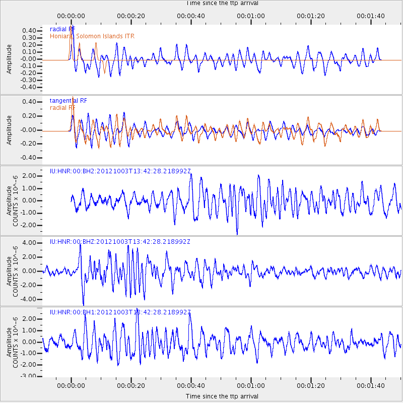
HNR Honiara, Solomon Islands - Earthquake Result Viewer
*The percent match for this event was below the threshold and hence no stack was calculated.
| Earthquake location: |
Southwest Of Sumatra, Indonesia |
| Earthquake latitude/longitude: |
-0.4/97.7 |
| Earthquake time(UTC): |
2012/10/03 (277) 13:32:34 GMT |
| Earthquake Depth: |
9.0 km |
| Earthquake Magnitude: |
5.6 MB, 5.5 MS, 5.7 MW, 5.5 MW |
| Earthquake Catalog/Contributor: |
WHDF/NEIC |
|
| Network: |
IU Global Seismograph Network (GSN - IRIS/USGS) |
| Station: |
HNR Honiara, Solomon Islands |
| Lat/Lon: |
9.44 S/159.95 E |
| Elevation: |
100 m |
|
| Distance: |
62.6 deg |
| Az: |
100.35 deg |
| Baz: |
274.422 deg |
| Ray Param: |
$rayparam |
*The percent match for this event was below the threshold and hence was not used in the summary stack. |
|
| Radial Match: |
66.01399 % |
| Radial Bump: |
400 |
| Transverse Match: |
62.94084 % |
| Transverse Bump: |
400 |
| SOD ConfigId: |
558545 |
| Insert Time: |
2013-09-17 19:49:58.654 +0000 |
| GWidth: |
2.5 |
| Max Bumps: |
400 |
| Tol: |
0.001 |
|
Signal To Noise
| Channel | StoN | STA | LTA |
| IU:HNR:00:BHZ:20121003T13:42:28.218992Z | 4.9462614 | 1.8205583E-6 | 3.6806753E-7 |
| IU:HNR:00:BH1:20121003T13:42:28.218992Z | 2.0370724 | 8.9813227E-7 | 4.4089364E-7 |
| IU:HNR:00:BH2:20121003T13:42:28.218992Z | 1.6264597 | 7.0820545E-7 | 4.3542758E-7 |
| Arrivals |
| Ps | |
| PpPs | |
| PsPs/PpSs | |


