You are here: Home > Network List > IU - Global Seismograph Network (GSN - IRIS/USGS) Stations List
> Station MAJO Matsushiro, Japan > Earthquake Result Viewer
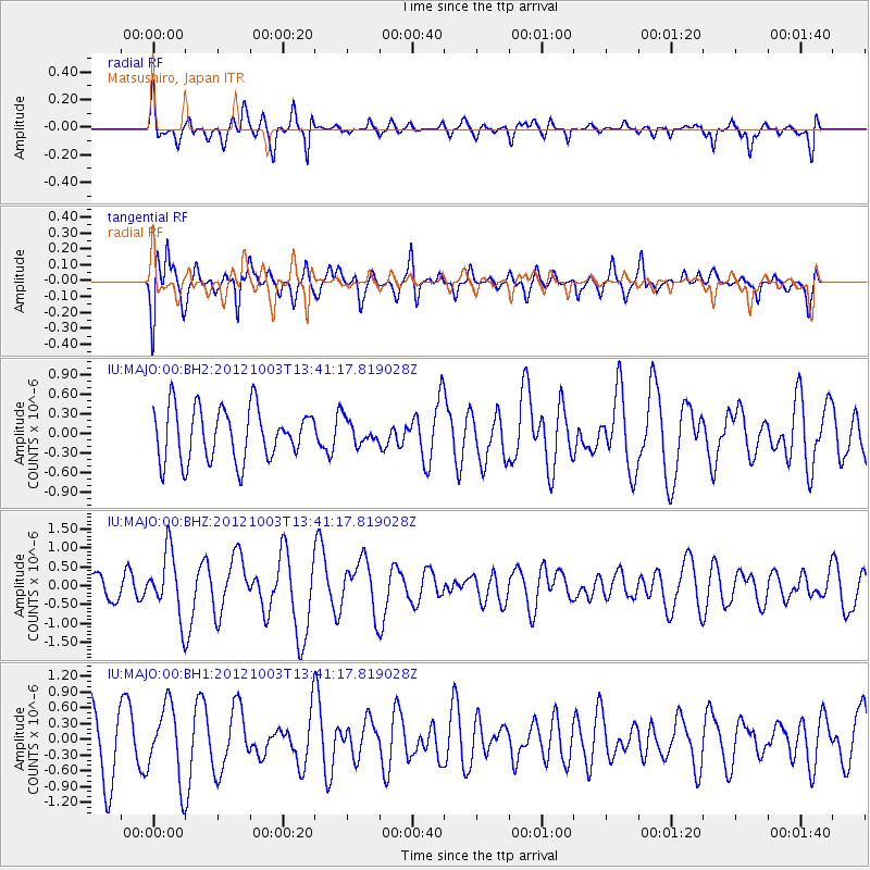
MAJO Matsushiro, Japan - Earthquake Result Viewer
*The percent match for this event was below the threshold and hence no stack was calculated.
| Earthquake location: |
Southwest Of Sumatra, Indonesia |
| Earthquake latitude/longitude: |
-0.4/97.7 |
| Earthquake time(UTC): |
2012/10/03 (277) 13:32:34 GMT |
| Earthquake Depth: |
9.0 km |
| Earthquake Magnitude: |
5.6 MB, 5.5 MS, 5.7 MW, 5.5 MW |
| Earthquake Catalog/Contributor: |
WHDF/NEIC |
|
| Network: |
IU Global Seismograph Network (GSN - IRIS/USGS) |
| Station: |
MAJO Matsushiro, Japan |
| Lat/Lon: |
36.55 N/138.20 E |
| Elevation: |
405 m |
|
| Distance: |
52.6 deg |
| Az: |
41.218 deg |
| Baz: |
234.908 deg |
| Ray Param: |
$rayparam |
*The percent match for this event was below the threshold and hence was not used in the summary stack. |
|
| Radial Match: |
53.010437 % |
| Radial Bump: |
400 |
| Transverse Match: |
60.311222 % |
| Transverse Bump: |
400 |
| SOD ConfigId: |
558545 |
| Insert Time: |
2013-09-17 19:50:19.718 +0000 |
| GWidth: |
2.5 |
| Max Bumps: |
400 |
| Tol: |
0.001 |
|
Signal To Noise
| Channel | StoN | STA | LTA |
| IU:MAJO:00:BHZ:20121003T13:41:17.819028Z | 2.546537 | 8.44231E-7 | 3.3152122E-7 |
| IU:MAJO:00:BH1:20121003T13:41:17.819028Z | 1.2494999 | 7.0742453E-7 | 5.6616614E-7 |
| IU:MAJO:00:BH2:20121003T13:41:17.819028Z | 0.46017125 | 1.840969E-7 | 4.0006174E-7 |
| Arrivals |
| Ps | |
| PpPs | |
| PsPs/PpSs | |


