You are here: Home > Network List > US - United States National Seismic Network Stations List
> Station HLID Hailey, Idaho, USA > Earthquake Result Viewer
HLID Hailey, Idaho, USA - Earthquake Result Viewer
*The percent match for this event was below the threshold and hence no stack was calculated.
| Earthquake location: |
Northern Mid-Atlantic Ridge |
| Earthquake latitude/longitude: |
17.4/-46.5 |
| Earthquake time(UTC): |
2012/10/04 (278) 23:14:56 GMT |
| Earthquake Depth: |
10 km |
| Earthquake Magnitude: |
5.5 MW, 5.0 MS, 5.4 MW, 5.3 MB |
| Earthquake Catalog/Contributor: |
WHDF/NEIC |
|
| Network: |
US United States National Seismic Network |
| Station: |
HLID Hailey, Idaho, USA |
| Lat/Lon: |
43.56 N/114.41 W |
| Elevation: |
1772 m |
|
| Distance: |
62.3 deg |
| Az: |
310.441 deg |
| Baz: |
91.935 deg |
| Ray Param: |
$rayparam |
*The percent match for this event was below the threshold and hence was not used in the summary stack. |
|
| Radial Match: |
56.541767 % |
| Radial Bump: |
400 |
| Transverse Match: |
65.68945 % |
| Transverse Bump: |
382 |
| SOD ConfigId: |
558545 |
| Insert Time: |
2013-09-17 19:54:23.022 +0000 |
| GWidth: |
2.5 |
| Max Bumps: |
400 |
| Tol: |
0.001 |
|
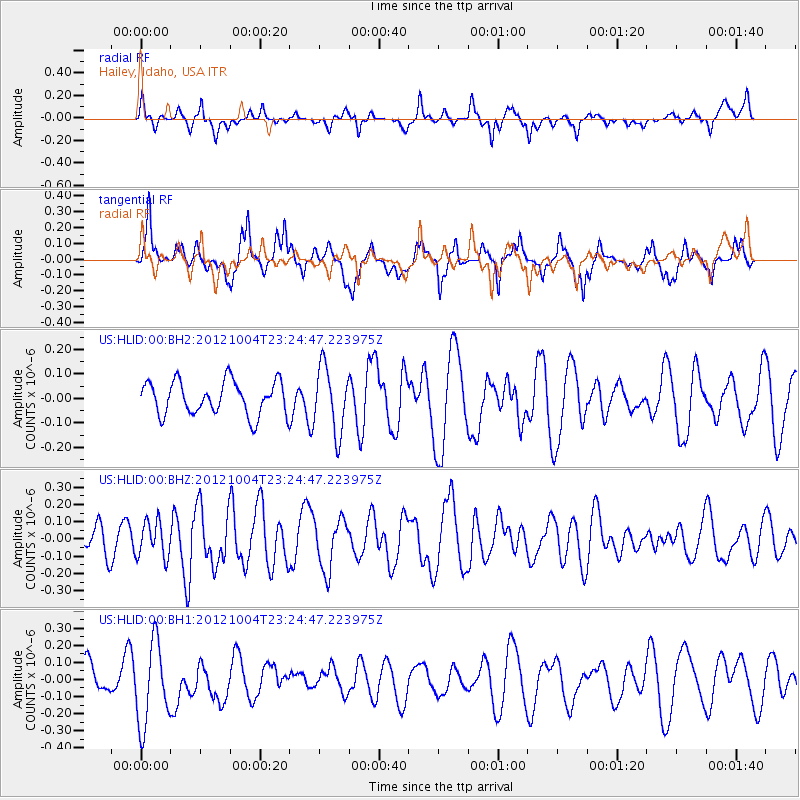
Signal To Noise
| Channel | StoN | STA | LTA |
| US:HLID:00:BHZ:20121004T23:24:47.223975Z | 0.96290475 | 1.03863655E-7 | 1.0786493E-7 |
| US:HLID:00:BH1:20121004T23:24:47.223975Z | 2.5847635 | 2.4285885E-7 | 9.395785E-8 |
| US:HLID:00:BH2:20121004T23:24:47.223975Z | 1.9751264 | 1.338804E-7 | 6.7783205E-8 |
| Arrivals |
| Ps | |
| PpPs | |
| PsPs/PpSs | |


