You are here: Home > Network List > US - United States National Seismic Network Stations List
> Station CBKS Cedar Bluff, Kansas, USA > Earthquake Result Viewer
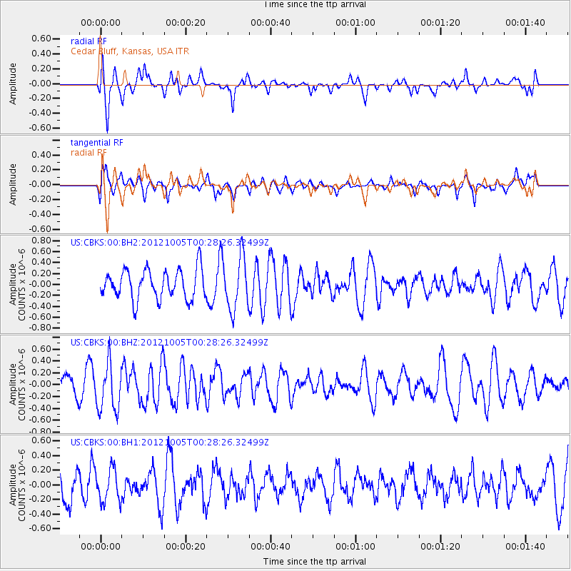
CBKS Cedar Bluff, Kansas, USA - Earthquake Result Viewer
*The percent match for this event was below the threshold and hence no stack was calculated.
| Earthquake location: |
Northern Mid-Atlantic Ridge |
| Earthquake latitude/longitude: |
17.5/-46.5 |
| Earthquake time(UTC): |
2012/10/05 (279) 00:19:56 GMT |
| Earthquake Depth: |
10 km |
| Earthquake Magnitude: |
5.7 MW, 5.3 MS, 5.2 MB, 5.5 MW |
| Earthquake Catalog/Contributor: |
WHDF/NEIC |
|
| Network: |
US United States National Seismic Network |
| Station: |
CBKS Cedar Bluff, Kansas, USA |
| Lat/Lon: |
38.81 N/99.74 W |
| Elevation: |
677 m |
|
| Distance: |
50.8 deg |
| Az: |
306.081 deg |
| Baz: |
99.133 deg |
| Ray Param: |
$rayparam |
*The percent match for this event was below the threshold and hence was not used in the summary stack. |
|
| Radial Match: |
53.751705 % |
| Radial Bump: |
379 |
| Transverse Match: |
64.76898 % |
| Transverse Bump: |
400 |
| SOD ConfigId: |
558545 |
| Insert Time: |
2013-09-17 19:58:25.709 +0000 |
| GWidth: |
2.5 |
| Max Bumps: |
400 |
| Tol: |
0.001 |
|
Signal To Noise
| Channel | StoN | STA | LTA |
| US:CBKS:00:BHZ:20121005T00:28:26.32499Z | 3.7366753 | 4.0855633E-7 | 1.0933686E-7 |
| US:CBKS:00:BH1:20121005T00:28:26.32499Z | 0.93881166 | 2.2424292E-7 | 2.3885826E-7 |
| US:CBKS:00:BH2:20121005T00:28:26.32499Z | 1.7971294 | 4.8111525E-7 | 2.677132E-7 |
| Arrivals |
| Ps | |
| PpPs | |
| PsPs/PpSs | |


