You are here: Home > Network List > IU - Global Seismograph Network (GSN - IRIS/USGS) Stations List
> Station RSSD Black Hills, South Dakota, USA > Earthquake Result Viewer
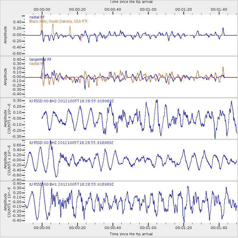
RSSD Black Hills, South Dakota, USA - Earthquake Result Viewer
*The percent match for this event was below the threshold and hence no stack was calculated.
| Earthquake location: |
Near Coast Of Guatemala |
| Earthquake latitude/longitude: |
13.0/-91.5 |
| Earthquake time(UTC): |
2012/10/05 (279) 18:22:56 GMT |
| Earthquake Depth: |
41 km |
| Earthquake Magnitude: |
5.5 MW, 5.5 MW |
| Earthquake Catalog/Contributor: |
NEIC PDE/NEIC PDE-W |
|
| Network: |
IU Global Seismograph Network (GSN - IRIS/USGS) |
| Station: |
RSSD Black Hills, South Dakota, USA |
| Lat/Lon: |
44.12 N/104.04 W |
| Elevation: |
2090 m |
|
| Distance: |
32.8 deg |
| Az: |
343.232 deg |
| Baz: |
157.021 deg |
| Ray Param: |
$rayparam |
*The percent match for this event was below the threshold and hence was not used in the summary stack. |
|
| Radial Match: |
38.46758 % |
| Radial Bump: |
400 |
| Transverse Match: |
83.76831 % |
| Transverse Bump: |
400 |
| SOD ConfigId: |
558545 |
| Insert Time: |
2013-09-17 20:01:27.291 +0000 |
| GWidth: |
2.5 |
| Max Bumps: |
400 |
| Tol: |
0.001 |
|
Signal To Noise
| Channel | StoN | STA | LTA |
| IU:RSSD:00:BHZ:20121005T18:28:55.918989Z | 2.1501594 | 4.0190974E-7 | 1.869209E-7 |
| IU:RSSD:00:BH1:20121005T18:28:55.918989Z | 2.9548748 | 2.7473467E-7 | 9.297676E-8 |
| IU:RSSD:00:BH2:20121005T18:28:55.918989Z | 0.87275445 | 9.2631026E-8 | 1.0613641E-7 |
| Arrivals |
| Ps | |
| PpPs | |
| PsPs/PpSs | |


