You are here: Home > Network List > II - Global Seismograph Network (GSN - IRIS/IDA) Stations List
> Station CMLA Cha de Macela, Sao Miguel Island, Azores > Earthquake Result Viewer
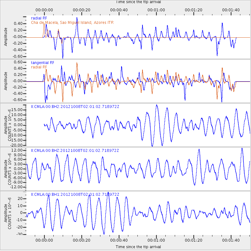
CMLA Cha de Macela, Sao Miguel Island, Azores - Earthquake Result Viewer
*The percent match for this event was below the threshold and hence no stack was calculated.
| Earthquake location: |
Chile-Bolivia Border Region |
| Earthquake latitude/longitude: |
-21.7/-68.2 |
| Earthquake time(UTC): |
2012/10/08 (282) 01:50:26 GMT |
| Earthquake Depth: |
122 km |
| Earthquake Magnitude: |
6.0 MB, 5.7 MW, 5.8 MW |
| Earthquake Catalog/Contributor: |
WHDF/NEIC |
|
| Network: |
II Global Seismograph Network (GSN - IRIS/IDA) |
| Station: |
CMLA Cha de Macela, Sao Miguel Island, Azores |
| Lat/Lon: |
37.76 N/25.52 W |
| Elevation: |
429 m |
|
| Distance: |
71.5 deg |
| Az: |
34.484 deg |
| Baz: |
221.626 deg |
| Ray Param: |
$rayparam |
*The percent match for this event was below the threshold and hence was not used in the summary stack. |
|
| Radial Match: |
60.72716 % |
| Radial Bump: |
367 |
| Transverse Match: |
60.880577 % |
| Transverse Bump: |
343 |
| SOD ConfigId: |
558545 |
| Insert Time: |
2013-09-17 20:08:11.749 +0000 |
| GWidth: |
2.5 |
| Max Bumps: |
400 |
| Tol: |
0.001 |
|
Signal To Noise
| Channel | StoN | STA | LTA |
| II:CMLA:00:BHZ:20121008T02:01:02.718972Z | 1.051658 | 3.6729639E-6 | 3.4925458E-6 |
| II:CMLA:00:BH1:20121008T02:01:02.718972Z | 1.7333394 | 1.6909808E-5 | 9.755624E-6 |
| II:CMLA:00:BH2:20121008T02:01:02.718972Z | 1.3578415 | 4.9933587E-6 | 3.6774238E-6 |
| Arrivals |
| Ps | |
| PpPs | |
| PsPs/PpSs | |


