You are here: Home > Network List > IU - Global Seismograph Network (GSN - IRIS/USGS) Stations List
> Station RSSD Black Hills, South Dakota, USA > Earthquake Result Viewer
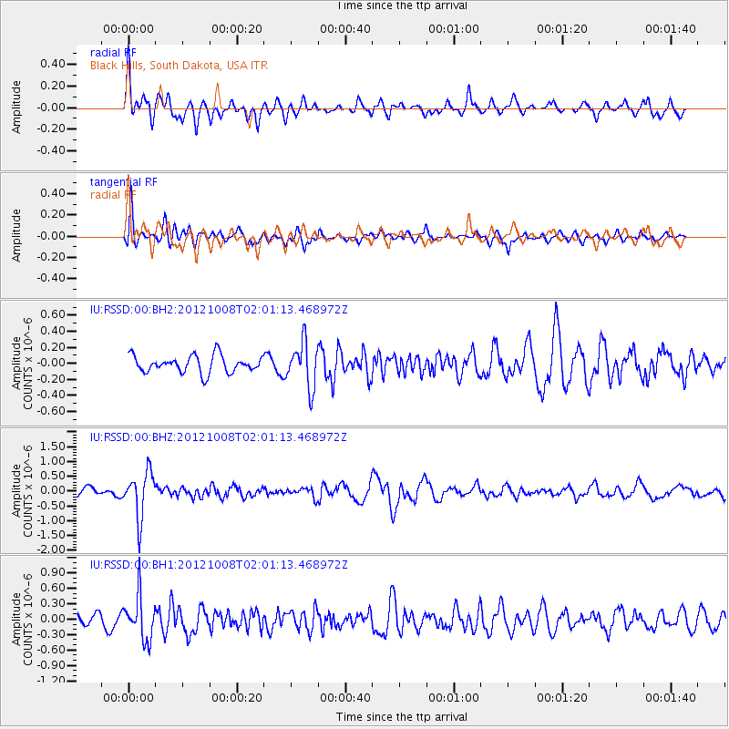
RSSD Black Hills, South Dakota, USA - Earthquake Result Viewer
*The percent match for this event was below the threshold and hence no stack was calculated.
| Earthquake location: |
Chile-Bolivia Border Region |
| Earthquake latitude/longitude: |
-21.7/-68.2 |
| Earthquake time(UTC): |
2012/10/08 (282) 01:50:26 GMT |
| Earthquake Depth: |
122 km |
| Earthquake Magnitude: |
6.0 MB, 5.7 MW, 5.8 MW |
| Earthquake Catalog/Contributor: |
WHDF/NEIC |
|
| Network: |
IU Global Seismograph Network (GSN - IRIS/USGS) |
| Station: |
RSSD Black Hills, South Dakota, USA |
| Lat/Lon: |
44.12 N/104.04 W |
| Elevation: |
2090 m |
|
| Distance: |
73.3 deg |
| Az: |
333.858 deg |
| Baz: |
145.332 deg |
| Ray Param: |
$rayparam |
*The percent match for this event was below the threshold and hence was not used in the summary stack. |
|
| Radial Match: |
73.160095 % |
| Radial Bump: |
400 |
| Transverse Match: |
57.2609 % |
| Transverse Bump: |
400 |
| SOD ConfigId: |
558545 |
| Insert Time: |
2013-09-17 20:09:21.922 +0000 |
| GWidth: |
2.5 |
| Max Bumps: |
400 |
| Tol: |
0.001 |
|
Signal To Noise
| Channel | StoN | STA | LTA |
| IU:RSSD:00:BHZ:20121008T02:01:13.468972Z | 5.74585 | 7.8597816E-7 | 1.3679059E-7 |
| IU:RSSD:00:BH1:20121008T02:01:13.468972Z | 3.4280362 | 4.263669E-7 | 1.2437643E-7 |
| IU:RSSD:00:BH2:20121008T02:01:13.468972Z | 2.6807604 | 2.8445203E-7 | 1.0610871E-7 |
| Arrivals |
| Ps | |
| PpPs | |
| PsPs/PpSs | |


