You are here: Home > Network List > US - United States National Seismic Network Stations List
> Station EGMT Eagleton, Montana, USA > Earthquake Result Viewer
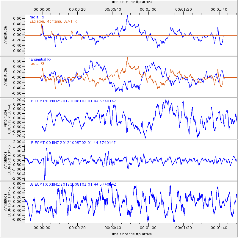
EGMT Eagleton, Montana, USA - Earthquake Result Viewer
*The percent match for this event was below the threshold and hence no stack was calculated.
| Earthquake location: |
Chile-Bolivia Border Region |
| Earthquake latitude/longitude: |
-21.7/-68.2 |
| Earthquake time(UTC): |
2012/10/08 (282) 01:50:26 GMT |
| Earthquake Depth: |
122 km |
| Earthquake Magnitude: |
6.0 MB, 5.7 MW, 5.8 MW |
| Earthquake Catalog/Contributor: |
WHDF/NEIC |
|
| Network: |
US United States National Seismic Network |
| Station: |
EGMT Eagleton, Montana, USA |
| Lat/Lon: |
48.02 N/109.75 W |
| Elevation: |
1055 m |
|
| Distance: |
78.8 deg |
| Az: |
332.984 deg |
| Baz: |
141.011 deg |
| Ray Param: |
$rayparam |
*The percent match for this event was below the threshold and hence was not used in the summary stack. |
|
| Radial Match: |
52.433628 % |
| Radial Bump: |
400 |
| Transverse Match: |
44.588146 % |
| Transverse Bump: |
400 |
| SOD ConfigId: |
558545 |
| Insert Time: |
2013-09-17 20:11:03.336 +0000 |
| GWidth: |
2.5 |
| Max Bumps: |
400 |
| Tol: |
0.001 |
|
Signal To Noise
| Channel | StoN | STA | LTA |
| US:EGMT:00:BHZ:20121008T02:01:44.574014Z | 5.254994 | 8.5042507E-7 | 1.6183179E-7 |
| US:EGMT:00:BH1:20121008T02:01:44.574014Z | 0.8937261 | 3.584065E-7 | 4.01025E-7 |
| US:EGMT:00:BH2:20121008T02:01:44.574014Z | 1.0715826 | 3.4784927E-7 | 3.2461264E-7 |
| Arrivals |
| Ps | |
| PpPs | |
| PsPs/PpSs | |


