You are here: Home > Network List > US - United States National Seismic Network Stations List
> Station HAWA Hanford, Washington, USA > Earthquake Result Viewer
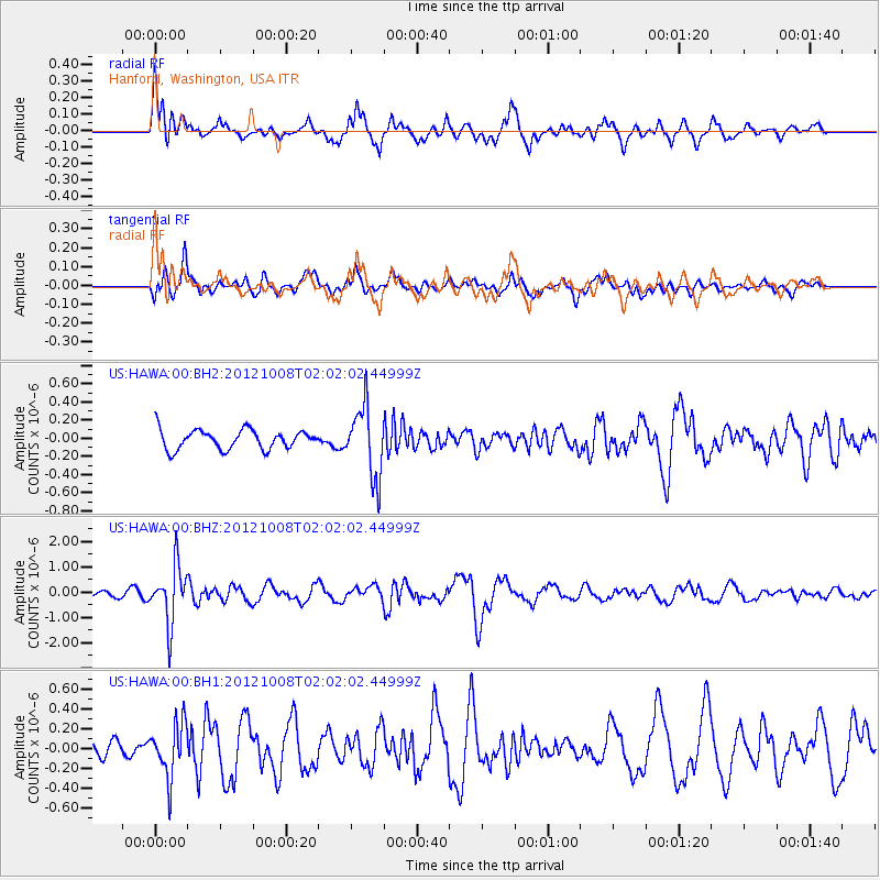
HAWA Hanford, Washington, USA - Earthquake Result Viewer
*The percent match for this event was below the threshold and hence no stack was calculated.
| Earthquake location: |
Chile-Bolivia Border Region |
| Earthquake latitude/longitude: |
-21.7/-68.2 |
| Earthquake time(UTC): |
2012/10/08 (282) 01:50:26 GMT |
| Earthquake Depth: |
122 km |
| Earthquake Magnitude: |
6.0 MB, 5.7 MW, 5.8 MW |
| Earthquake Catalog/Contributor: |
WHDF/NEIC |
|
| Network: |
US United States National Seismic Network |
| Station: |
HAWA Hanford, Washington, USA |
| Lat/Lon: |
46.39 N/119.53 W |
| Elevation: |
364 m |
|
| Distance: |
82.2 deg |
| Az: |
326.923 deg |
| Baz: |
132.847 deg |
| Ray Param: |
$rayparam |
*The percent match for this event was below the threshold and hence was not used in the summary stack. |
|
| Radial Match: |
68.88846 % |
| Radial Bump: |
400 |
| Transverse Match: |
49.09008 % |
| Transverse Bump: |
400 |
| SOD ConfigId: |
558545 |
| Insert Time: |
2013-09-17 20:11:23.305 +0000 |
| GWidth: |
2.5 |
| Max Bumps: |
400 |
| Tol: |
0.001 |
|
Signal To Noise
| Channel | StoN | STA | LTA |
| US:HAWA:00:BHZ:20121008T02:02:02.44999Z | 8.4487505 | 1.1327894E-6 | 1.3407774E-7 |
| US:HAWA:00:BH1:20121008T02:02:02.44999Z | 4.2751403 | 2.6959847E-7 | 6.30619E-8 |
| US:HAWA:00:BH2:20121008T02:02:02.44999Z | 3.6270247 | 3.8288627E-7 | 1.05564844E-7 |
| Arrivals |
| Ps | |
| PpPs | |
| PsPs/PpSs | |


