You are here: Home > Network List > IU - Global Seismograph Network (GSN - IRIS/USGS) Stations List
> Station OTAV Otavalo, Ecuador > Earthquake Result Viewer
OTAV Otavalo, Ecuador - Earthquake Result Viewer
| Earthquake location: |
Gulf Of California |
| Earthquake latitude/longitude: |
25.1/-109.6 |
| Earthquake time(UTC): |
2012/10/08 (282) 06:26:23 GMT |
| Earthquake Depth: |
14 km |
| Earthquake Magnitude: |
6.0 MW, 5.6 MB, 5.7 MS, 5.9 MW |
| Earthquake Catalog/Contributor: |
NEIC PDE/NEIC PDE-W |
|
| Network: |
IU Global Seismograph Network (GSN - IRIS/USGS) |
| Station: |
OTAV Otavalo, Ecuador |
| Lat/Lon: |
0.24 N/78.45 W |
| Elevation: |
3510 m |
|
| Distance: |
38.9 deg |
| Az: |
124.69 deg |
| Baz: |
311.812 deg |
| Ray Param: |
0.07525707 |
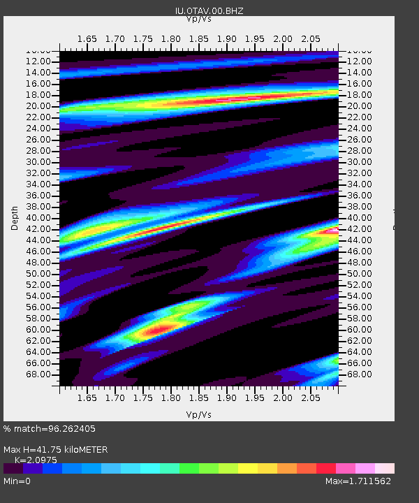
| Estimated Moho Depth: |
41.75 km |
| Estimated Crust Vp/Vs: |
2.10 |
| Assumed Crust Vp: |
6.472 km/s |
| Estimated Crust Vs: |
3.086 km/s |
| Estimated Crust Poisson's Ratio: |
0.35 |
|
| Radial Match: |
96.262405 % |
| Radial Bump: |
362 |
| Transverse Match: |
85.78693 % |
| Transverse Bump: |
400 |
| SOD ConfigId: |
558545 |
| Insert Time: |
2013-09-17 20:15:17.566 +0000 |
| GWidth: |
2.5 |
| Max Bumps: |
400 |
| Tol: |
0.001 |
|
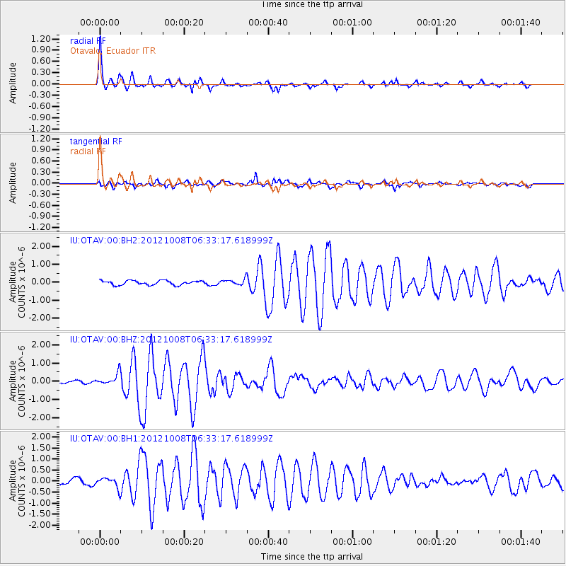
Signal To Noise
| Channel | StoN | STA | LTA |
| IU:OTAV:00:BHZ:20121008T06:33:17.618999Z | 5.353038 | 3.2878006E-7 | 6.141934E-8 |
| IU:OTAV:00:BH1:20121008T06:33:17.618999Z | 2.1636403 | 2.3639875E-7 | 1.0925973E-7 |
| IU:OTAV:00:BH2:20121008T06:33:17.618999Z | 1.411267 | 1.6668652E-7 | 1.1811125E-7 |
| Arrivals |
| Ps | 7.5 SECOND |
| PpPs | 19 SECOND |
| PsPs/PpSs | 26 SECOND |


