You are here: Home > Network List > IU - Global Seismograph Network (GSN - IRIS/USGS) Stations List
> Station HNR Honiara, Solomon Islands > Earthquake Result Viewer
HNR Honiara, Solomon Islands - Earthquake Result Viewer
| Earthquake location: |
Banda Sea |
| Earthquake latitude/longitude: |
-4.5/129.1 |
| Earthquake time(UTC): |
2012/10/08 (282) 11:43:31 GMT |
| Earthquake Depth: |
10 km |
| Earthquake Magnitude: |
6.3 MW, 6.0 MS, 6.1 MW, 6.3 MB |
| Earthquake Catalog/Contributor: |
NEIC PDE/NEIC PDE-W |
|
| Network: |
IU Global Seismograph Network (GSN - IRIS/USGS) |
| Station: |
HNR Honiara, Solomon Islands |
| Lat/Lon: |
9.44 S/159.95 E |
| Elevation: |
100 m |
|
| Distance: |
31.0 deg |
| Az: |
100.842 deg |
| Baz: |
277.04 deg |
| Ray Param: |
0.07919104 |
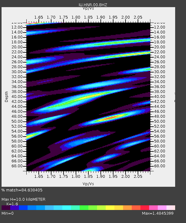
| Estimated Moho Depth: |
10.0 km |
| Estimated Crust Vp/Vs: |
1.60 |
| Assumed Crust Vp: |
6.183 km/s |
| Estimated Crust Vs: |
3.864 km/s |
| Estimated Crust Poisson's Ratio: |
0.18 |
|
| Radial Match: |
84.638405 % |
| Radial Bump: |
400 |
| Transverse Match: |
84.81524 % |
| Transverse Bump: |
400 |
| SOD ConfigId: |
558545 |
| Insert Time: |
2013-09-17 20:17:44.401 +0000 |
| GWidth: |
2.5 |
| Max Bumps: |
400 |
| Tol: |
0.001 |
|
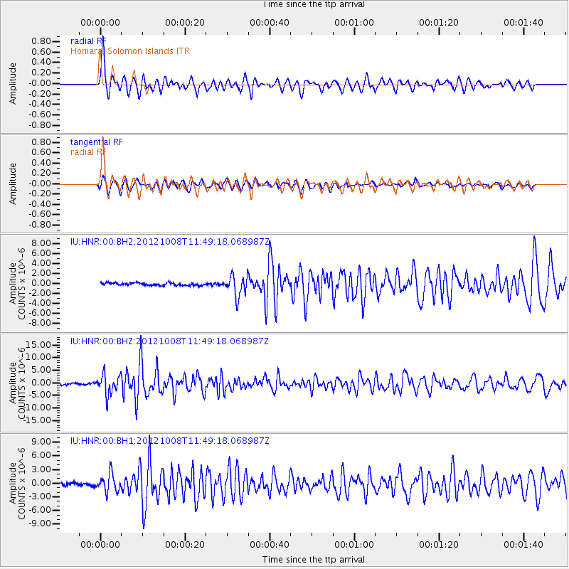
Signal To Noise
| Channel | StoN | STA | LTA |
| IU:HNR:00:BHZ:20121008T11:49:18.068987Z | 13.333623 | 4.045082E-6 | 3.0337452E-7 |
| IU:HNR:00:BH1:20121008T11:49:18.068987Z | 6.7583275 | 2.0027217E-6 | 2.963339E-7 |
| IU:HNR:00:BH2:20121008T11:49:18.068987Z | 8.376997 | 2.101988E-6 | 2.5092382E-7 |
| Arrivals |
| Ps | 1.1 SECOND |
| PpPs | 3.9 SECOND |
| PsPs/PpSs | 4.9 SECOND |


