You are here: Home > Network List > IU - Global Seismograph Network (GSN - IRIS/USGS) Stations List
> Station MAKZ Makanchi, Kazakhstan > Earthquake Result Viewer
MAKZ Makanchi, Kazakhstan - Earthquake Result Viewer
*The percent match for this event was below the threshold and hence no stack was calculated.
| Earthquake location: |
Near North Coast Of Irian Jaya |
| Earthquake latitude/longitude: |
-2.7/139.2 |
| Earthquake time(UTC): |
2012/10/09 (283) 07:49:51 GMT |
| Earthquake Depth: |
20 km |
| Earthquake Magnitude: |
5.6 MB, 5.4 MS, 5.6 MW |
| Earthquake Catalog/Contributor: |
WHDF/NEIC |
|
| Network: |
IU Global Seismograph Network (GSN - IRIS/USGS) |
| Station: |
MAKZ Makanchi, Kazakhstan |
| Lat/Lon: |
46.81 N/81.98 E |
| Elevation: |
600 m |
|
| Distance: |
70.3 deg |
| Az: |
322.153 deg |
| Baz: |
116.842 deg |
| Ray Param: |
$rayparam |
*The percent match for this event was below the threshold and hence was not used in the summary stack. |
|
| Radial Match: |
71.0631 % |
| Radial Bump: |
375 |
| Transverse Match: |
74.32901 % |
| Transverse Bump: |
400 |
| SOD ConfigId: |
558545 |
| Insert Time: |
2013-09-17 20:19:52.950 +0000 |
| GWidth: |
2.5 |
| Max Bumps: |
400 |
| Tol: |
0.001 |
|
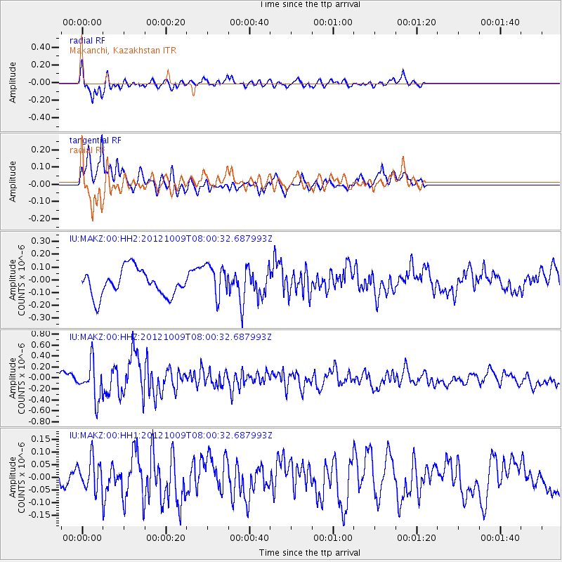
Signal To Noise
| Channel | StoN | STA | LTA |
| IU:MAKZ:00:HHZ:20121009T08:00:32.687993Z | 2.9368632 | 3.3710086E-7 | 1.1478262E-7 |
| IU:MAKZ:00:HH1:20121009T08:00:32.687993Z | 1.5378926 | 6.016293E-8 | 3.9120373E-8 |
| IU:MAKZ:00:HH2:20121009T08:00:32.687993Z | 1.2466826 | 1.2839668E-7 | 1.0299067E-7 |
| Arrivals |
| Ps | |
| PpPs | |
| PsPs/PpSs | |


