You are here: Home > Network List > IU - Global Seismograph Network (GSN - IRIS/USGS) Stations List
> Station TSUM Tsumeb, Namibia > Earthquake Result Viewer
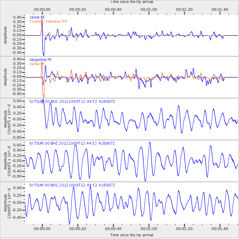
TSUM Tsumeb, Namibia - Earthquake Result Viewer
*The percent match for this event was below the threshold and hence no stack was calculated.
| Earthquake location: |
West Of Macquarie Island |
| Earthquake latitude/longitude: |
-60.3/153.7 |
| Earthquake time(UTC): |
2012/10/09 (283) 12:32:09 GMT |
| Earthquake Depth: |
10 km |
| Earthquake Magnitude: |
5.6 MB, 6.2 MS, 6.6 MW, 6.3 MW |
| Earthquake Catalog/Contributor: |
WHDF/NEIC |
|
| Network: |
IU Global Seismograph Network (GSN - IRIS/USGS) |
| Station: |
TSUM Tsumeb, Namibia |
| Lat/Lon: |
19.20 S/17.58 E |
| Elevation: |
1260 m |
|
| Distance: |
93.2 deg |
| Az: |
221.005 deg |
| Baz: |
159.79 deg |
| Ray Param: |
$rayparam |
*The percent match for this event was below the threshold and hence was not used in the summary stack. |
|
| Radial Match: |
71.19988 % |
| Radial Bump: |
400 |
| Transverse Match: |
53.789555 % |
| Transverse Bump: |
400 |
| SOD ConfigId: |
558545 |
| Insert Time: |
2013-09-17 20:22:07.126 +0000 |
| GWidth: |
2.5 |
| Max Bumps: |
400 |
| Tol: |
0.001 |
|
Signal To Noise
| Channel | StoN | STA | LTA |
| IU:TSUM:00:BHZ:20121009T12:44:52.418987Z | 1.8731663 | 2.8441775E-7 | 1.5183795E-7 |
| IU:TSUM:00:BH1:20121009T12:44:52.418987Z | 1.1569324 | 1.8031137E-7 | 1.55853E-7 |
| IU:TSUM:00:BH2:20121009T12:44:52.418987Z | 0.9319823 | 2.2959998E-7 | 2.4635656E-7 |
| Arrivals |
| Ps | |
| PpPs | |
| PsPs/PpSs | |


