You are here: Home > Network List > IU - Global Seismograph Network (GSN - IRIS/USGS) Stations List
> Station OTAV Otavalo, Ecuador > Earthquake Result Viewer
OTAV Otavalo, Ecuador - Earthquake Result Viewer
| Earthquake location: |
Chile-Argentina Border Region |
| Earthquake latitude/longitude: |
-32.9/-70.3 |
| Earthquake time(UTC): |
2012/10/11 (285) 17:22:09 GMT |
| Earthquake Depth: |
82 km |
| Earthquake Magnitude: |
5.5 MB, 5.5 MW, 5.6 MW |
| Earthquake Catalog/Contributor: |
WHDF/NEIC |
|
| Network: |
IU Global Seismograph Network (GSN - IRIS/USGS) |
| Station: |
OTAV Otavalo, Ecuador |
| Lat/Lon: |
0.24 N/78.45 W |
| Elevation: |
3510 m |
|
| Distance: |
33.8 deg |
| Az: |
345.257 deg |
| Baz: |
167.633 deg |
| Ray Param: |
0.077819355 |
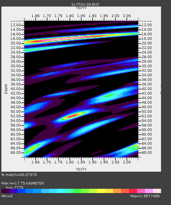
| Estimated Moho Depth: |
17.75 km |
| Estimated Crust Vp/Vs: |
1.78 |
| Assumed Crust Vp: |
6.472 km/s |
| Estimated Crust Vs: |
3.641 km/s |
| Estimated Crust Poisson's Ratio: |
0.27 |
|
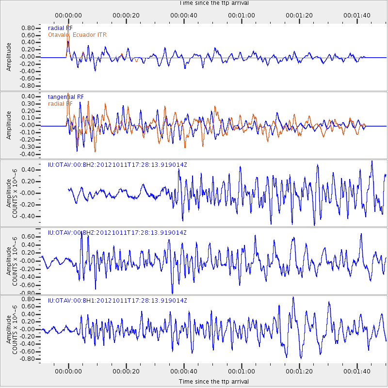
| Radial Match: |
80.07578 % |
| Radial Bump: |
400 |
| Transverse Match: |
74.10563 % |
| Transverse Bump: |
400 |
| SOD ConfigId: |
558545 |
| Insert Time: |
2013-09-17 20:23:24.094 +0000 |
| GWidth: |
2.5 |
| Max Bumps: |
400 |
| Tol: |
0.001 |
|
Signal To Noise
| Channel | StoN | STA | LTA |
| IU:OTAV:00:BHZ:20121011T17:28:13.919014Z | 3.8062248 | 2.541639E-7 | 6.6775854E-8 |
| IU:OTAV:00:BH1:20121011T17:28:13.919014Z | 1.9310861 | 1.1390647E-7 | 5.8985698E-8 |
| IU:OTAV:00:BH2:20121011T17:28:13.919014Z | 1.0761621 | 6.427956E-8 | 5.973037E-8 |
| Arrivals |
| Ps | 2.3 SECOND |
| PpPs | 7.0 SECOND |
| PsPs/PpSs | 9.4 SECOND |


