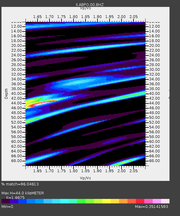
ABPO Ambohimpanompo, Madagascar - Earthquake Result Viewer

Earthquake location: Irian Jaya Region, Indonesia
Earthquake latitude/longitude: -4.9/134.0
Earthquake time(UTC): 2012/10/12 (286) 00:31:28 GMT
Earthquake Depth: 13 km
Earthquake Magnitude: 6.5 MW, 6.3 MB, 6.6 MS, 6.6 MW
Earthquake Catalog/Contributor: NEIC PDE/NEIC PDE-W
Network: II Global Seismograph Network (GSN - IRIS/IDA)
Station: ABPO Ambohimpanompo, Madagascar
Lat/Lon: 19.02 S/47.23 E
Elevation: 1528 m
Distance: 85.4 deg
Az: 251.379 deg
Baz: 93.574 deg
Ray Param: 0.04477995
Estimated Moho Depth: 44.0 km
Estimated Crust Vp/Vs: 1.67
Assumed Crust Vp: 6.642 km/s
Estimated Crust Vs: 3.983 km/s
Estimated Crust Poisson's Ratio: 0.22
Radial Match: 96.04613 %
Radial Bump: 352
Transverse Match: 74.04193 %
Transverse Bump: 400
SOD ConfigId: 558545
Insert Time: 2013-09-17 20:26:29.295 +0000
GWidth: 2.5
Max Bumps: 400
Tol: 0.001

Signal To Noise

ChannelStoNSTALTA
II:ABPO:00:BHZ:20121012T00:43:33.819011Z6.96421051.2942514E-61.8584323E-7
II:ABPO:00:BH1:20121012T00:43:33.819011Z1.6362383.157444E-71.9296972E-7
II:ABPO:00:BH2:20121012T00:43:33.819011Z1.63117334.5356734E-72.7806203E-7
Arrivals
Ps4.5 SECOND
PpPs17 SECOND
PsPs/PpSs22 SECOND