PALK Pallekele, Sri Lanka - Earthquake Result Viewer
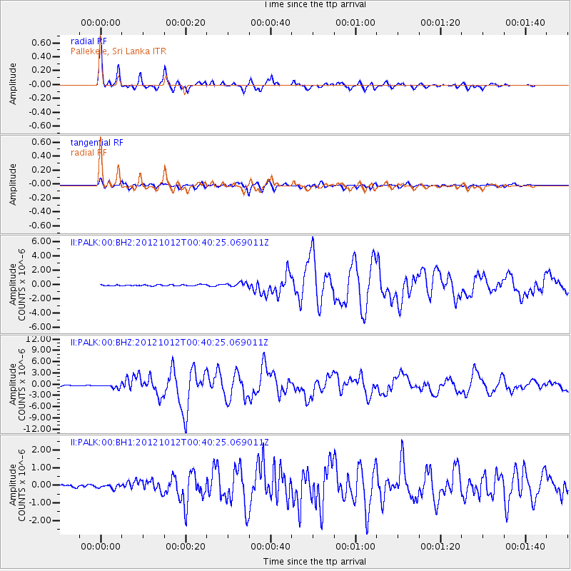
Earthquake location: Irian Jaya Region, Indonesia
Earthquake latitude/longitude: -4.9/134.0
Earthquake time(UTC): 2012/10/12 (286) 00:31:28 GMT
Earthquake Depth: 13 km
Earthquake Magnitude: 6.5 MW, 6.3 MB, 6.6 MS, 6.6 MW
Earthquake Catalog/Contributor: NEIC PDE/NEIC PDE-W
Network: II Global Seismograph Network (GSN - IRIS/IDA)
Station: PALK Pallekele, Sri Lanka
Lat/Lon: 7.27 N/80.70 E
Elevation: 460 m
Distance: 54.6 deg
Az: 282.438 deg
Baz: 101.244 deg
Ray Param: 0.06535879
Estimated Moho Depth: 39.75 km
Estimated Crust Vp/Vs: 1.65
Assumed Crust Vp: 6.545 km/s
Estimated Crust Vs: 3.961 km/s
Estimated Crust Poisson's Ratio: 0.21
Radial Match: 97.06485 %
Radial Bump: 316
Transverse Match: 85.54228 %
Transverse Bump: 400
SOD ConfigId: 558545
Insert Time: 2013-09-17 20:26:50.756 +0000
GWidth: 2.5
Max Bumps: 400
Tol: 0.001

Signal To Noise

ChannelStoNSTALTA
II:PALK:00:BHZ:20121012T00:40:25.069011Z3.89109685.0848195E-71.306783E-7
II:PALK:00:BH1:20121012T00:40:25.069011Z0.858286741.0650451E-71.2408967E-7
II:PALK:00:BH2:20121012T00:40:25.069011Z3.49259832.8348296E-78.116678E-8
Arrivals
Ps4.2 SECOND
PpPs15 SECOND
PsPs/PpSs19 SECOND