You are here: Home > Network List > US - United States National Seismic Network Stations List
> Station MSO Missoula, Montana, USA > Earthquake Result Viewer
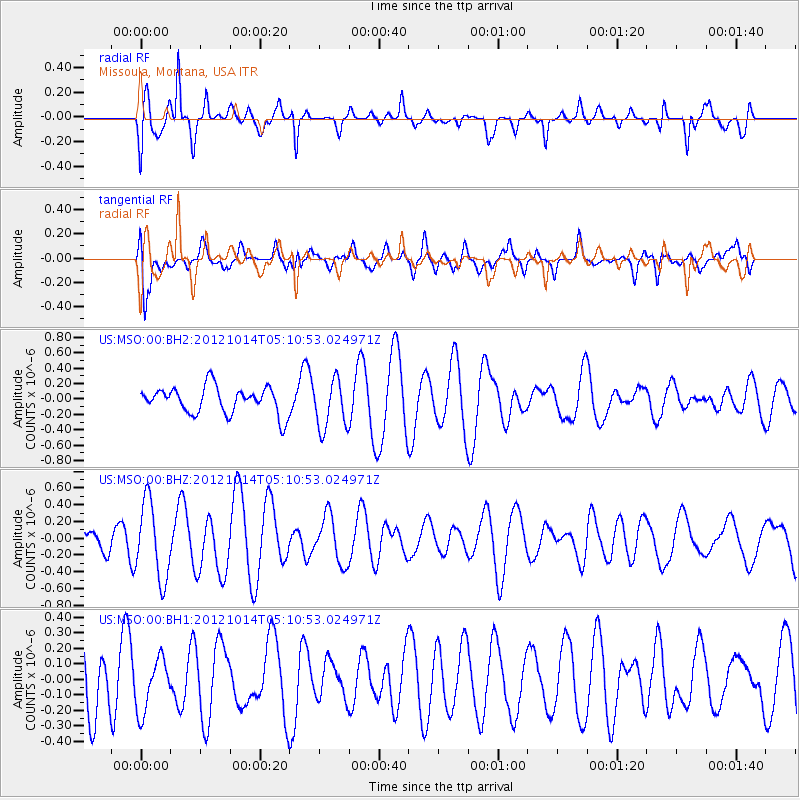
MSO Missoula, Montana, USA - Earthquake Result Viewer
*The percent match for this event was below the threshold and hence no stack was calculated.
| Earthquake location: |
Solomon Islands |
| Earthquake latitude/longitude: |
-7.1/156.0 |
| Earthquake time(UTC): |
2012/10/14 (288) 04:58:04 GMT |
| Earthquake Depth: |
37 km |
| Earthquake Magnitude: |
5.8 MB, 5.5 MS, 5.8 MW, 5.8 MW |
| Earthquake Catalog/Contributor: |
WHDF/NEIC |
|
| Network: |
US United States National Seismic Network |
| Station: |
MSO Missoula, Montana, USA |
| Lat/Lon: |
46.83 N/113.94 W |
| Elevation: |
1264 m |
|
| Distance: |
95.2 deg |
| Az: |
43.584 deg |
| Baz: |
265.122 deg |
| Ray Param: |
$rayparam |
*The percent match for this event was below the threshold and hence was not used in the summary stack. |
|
| Radial Match: |
76.686966 % |
| Radial Bump: |
400 |
| Transverse Match: |
43.43299 % |
| Transverse Bump: |
400 |
| SOD ConfigId: |
558545 |
| Insert Time: |
2013-09-17 20:30:25.190 +0000 |
| GWidth: |
2.5 |
| Max Bumps: |
400 |
| Tol: |
0.001 |
|
Signal To Noise
| Channel | StoN | STA | LTA |
| US:MSO:00:BHZ:20121014T05:10:53.024971Z | 3.154583 | 4.606903E-7 | 1.4603842E-7 |
| US:MSO:00:BH1:20121014T05:10:53.024971Z | 0.78536147 | 1.7062098E-7 | 2.1725151E-7 |
| US:MSO:00:BH2:20121014T05:10:53.024971Z | 1.8397211 | 3.2123856E-7 | 1.7461265E-7 |
| Arrivals |
| Ps | |
| PpPs | |
| PsPs/PpSs | |


