You are here: Home > Network List > US - United States National Seismic Network Stations List
> Station EGMT Eagleton, Montana, USA > Earthquake Result Viewer
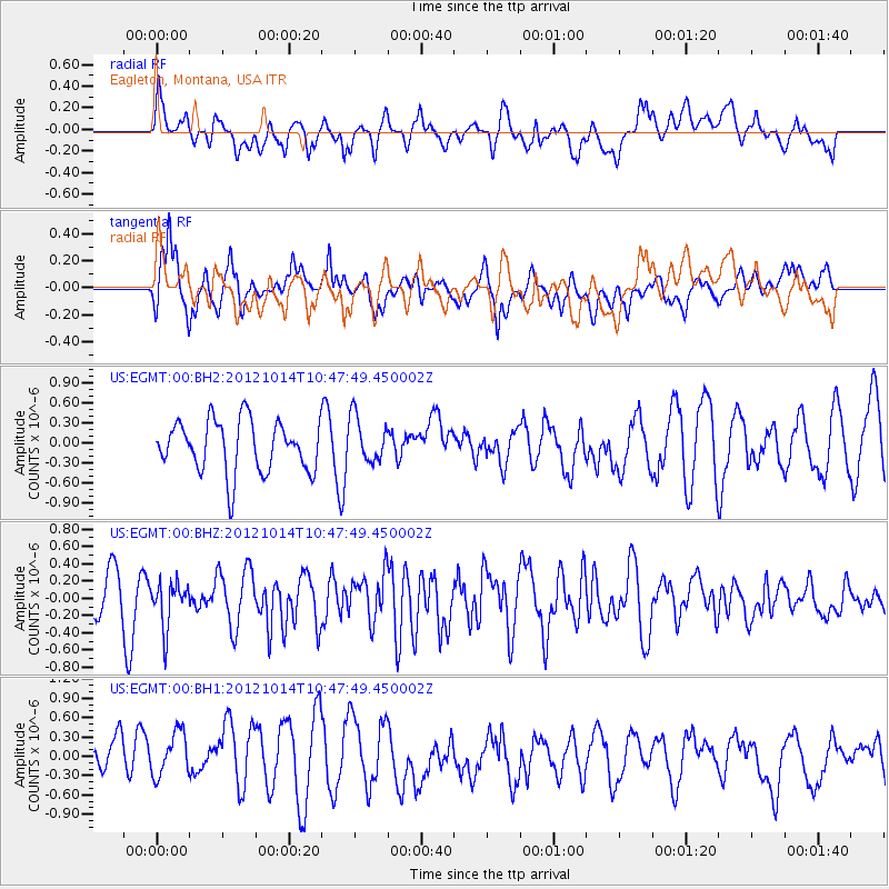
EGMT Eagleton, Montana, USA - Earthquake Result Viewer
*The percent match for this event was below the threshold and hence no stack was calculated.
| Earthquake location: |
Near Coast Of Chiapas, Mexico |
| Earthquake latitude/longitude: |
14.7/-92.3 |
| Earthquake time(UTC): |
2012/10/14 (288) 10:41:23 GMT |
| Earthquake Depth: |
69 km |
| Earthquake Magnitude: |
5.5 MW, 5.4 MB, 5.2 MD |
| Earthquake Catalog/Contributor: |
WHDF/NEIC |
|
| Network: |
US United States National Seismic Network |
| Station: |
EGMT Eagleton, Montana, USA |
| Lat/Lon: |
48.02 N/109.75 W |
| Elevation: |
1055 m |
|
| Distance: |
36.3 deg |
| Az: |
340.08 deg |
| Baz: |
150.583 deg |
| Ray Param: |
$rayparam |
*The percent match for this event was below the threshold and hence was not used in the summary stack. |
|
| Radial Match: |
55.239788 % |
| Radial Bump: |
400 |
| Transverse Match: |
67.172165 % |
| Transverse Bump: |
400 |
| SOD ConfigId: |
558545 |
| Insert Time: |
2013-09-17 20:39:57.893 +0000 |
| GWidth: |
2.5 |
| Max Bumps: |
400 |
| Tol: |
0.001 |
|
Signal To Noise
| Channel | StoN | STA | LTA |
| US:EGMT:00:BHZ:20121014T10:47:49.450002Z | 1.0168874 | 2.5973276E-7 | 2.554194E-7 |
| US:EGMT:00:BH1:20121014T10:47:49.450002Z | 0.99315184 | 3.8635977E-7 | 3.8902385E-7 |
| US:EGMT:00:BH2:20121014T10:47:49.450002Z | 0.8909169 | 3.4295587E-7 | 3.849471E-7 |
| Arrivals |
| Ps | |
| PpPs | |
| PsPs/PpSs | |


