You are here: Home > Network List > US - United States National Seismic Network Stations List
> Station EGMT Eagleton, Montana, USA > Earthquake Result Viewer
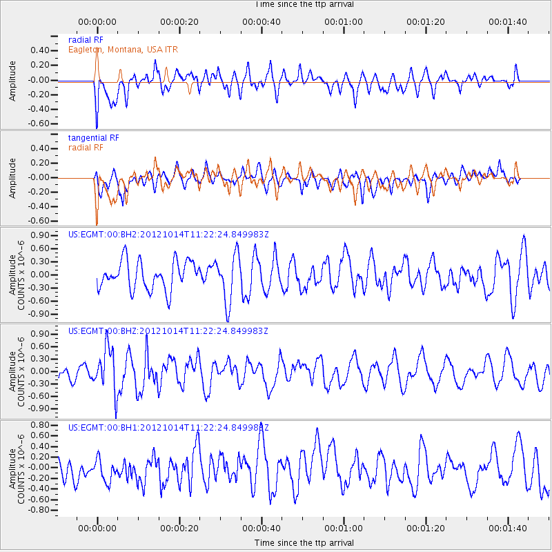
EGMT Eagleton, Montana, USA - Earthquake Result Viewer
*The percent match for this event was below the threshold and hence no stack was calculated.
| Earthquake location: |
Off East Coast Of Honshu, Japan |
| Earthquake latitude/longitude: |
38.2/144.3 |
| Earthquake time(UTC): |
2012/10/14 (288) 11:11:36 GMT |
| Earthquake Depth: |
34 km |
| Earthquake Magnitude: |
5.6 MB, 4.9 MS, 5.4 MW |
| Earthquake Catalog/Contributor: |
WHDF/NEIC |
|
| Network: |
US United States National Seismic Network |
| Station: |
EGMT Eagleton, Montana, USA |
| Lat/Lon: |
48.02 N/109.75 W |
| Elevation: |
1055 m |
|
| Distance: |
71.8 deg |
| Az: |
42.797 deg |
| Baz: |
307.134 deg |
| Ray Param: |
$rayparam |
*The percent match for this event was below the threshold and hence was not used in the summary stack. |
|
| Radial Match: |
61.417477 % |
| Radial Bump: |
400 |
| Transverse Match: |
56.327656 % |
| Transverse Bump: |
400 |
| SOD ConfigId: |
558545 |
| Insert Time: |
2013-09-17 20:43:42.054 +0000 |
| GWidth: |
2.5 |
| Max Bumps: |
400 |
| Tol: |
0.001 |
|
Signal To Noise
| Channel | StoN | STA | LTA |
| US:EGMT:00:BHZ:20121014T11:22:24.849983Z | 2.6997285 | 5.468824E-7 | 2.0256941E-7 |
| US:EGMT:00:BH1:20121014T11:22:24.849983Z | 0.87280315 | 2.4561245E-7 | 2.8140647E-7 |
| US:EGMT:00:BH2:20121014T11:22:24.849983Z | 1.7312125 | 5.5830446E-7 | 3.2249332E-7 |
| Arrivals |
| Ps | |
| PpPs | |
| PsPs/PpSs | |


