You are here: Home > Network List > IU - Global Seismograph Network (GSN - IRIS/USGS) Stations List
> Station GNI Garni, Armenia > Earthquake Result Viewer
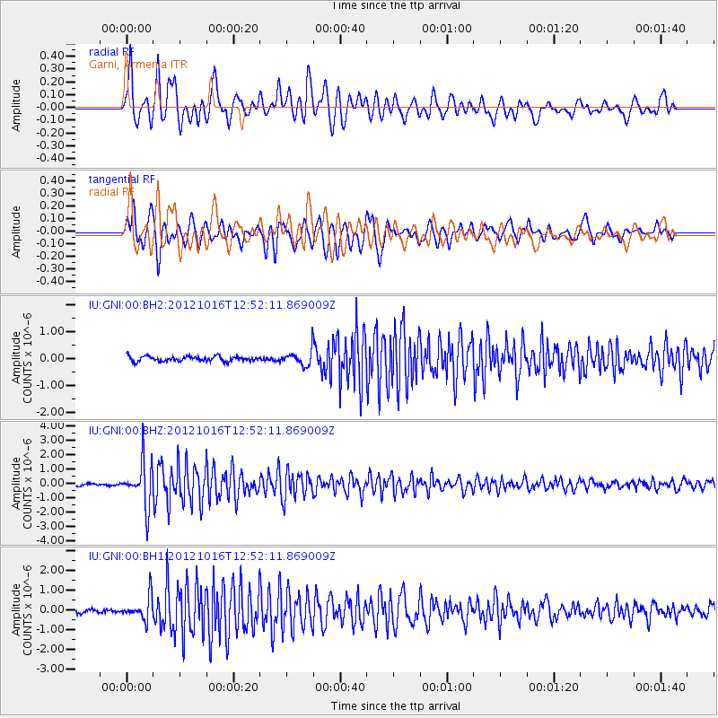
GNI Garni, Armenia - Earthquake Result Viewer
*The percent match for this event was below the threshold and hence no stack was calculated.
| Earthquake location: |
Kuril Islands |
| Earthquake latitude/longitude: |
49.6/156.4 |
| Earthquake time(UTC): |
2012/10/16 (290) 12:41:25 GMT |
| Earthquake Depth: |
81 km |
| Earthquake Magnitude: |
6.2 MB, 5.6 MW, 5.6 MW |
| Earthquake Catalog/Contributor: |
WHDF/NEIC |
|
| Network: |
IU Global Seismograph Network (GSN - IRIS/USGS) |
| Station: |
GNI Garni, Armenia |
| Lat/Lon: |
40.15 N/44.74 E |
| Elevation: |
1609 m |
|
| Distance: |
72.3 deg |
| Az: |
311.629 deg |
| Baz: |
39.364 deg |
| Ray Param: |
$rayparam |
*The percent match for this event was below the threshold and hence was not used in the summary stack. |
|
| Radial Match: |
76.60278 % |
| Radial Bump: |
400 |
| Transverse Match: |
72.63361 % |
| Transverse Bump: |
400 |
| SOD ConfigId: |
558545 |
| Insert Time: |
2013-09-17 20:53:21.270 +0000 |
| GWidth: |
2.5 |
| Max Bumps: |
400 |
| Tol: |
0.001 |
|
Signal To Noise
| Channel | StoN | STA | LTA |
| IU:GNI:00:BHZ:20121016T12:52:11.869009Z | 18.186357 | 1.538162E-6 | 8.457779E-8 |
| IU:GNI:00:BH1:20121016T12:52:11.869009Z | 6.82523 | 6.0213677E-7 | 8.822219E-8 |
| IU:GNI:00:BH2:20121016T12:52:11.869009Z | 3.0248322 | 2.765025E-7 | 9.1410854E-8 |
| Arrivals |
| Ps | |
| PpPs | |
| PsPs/PpSs | |


