You are here: Home > Network List > US - United States National Seismic Network Stations List
> Station ACSO Alum Creek State Park, Ohio, USA > Earthquake Result Viewer
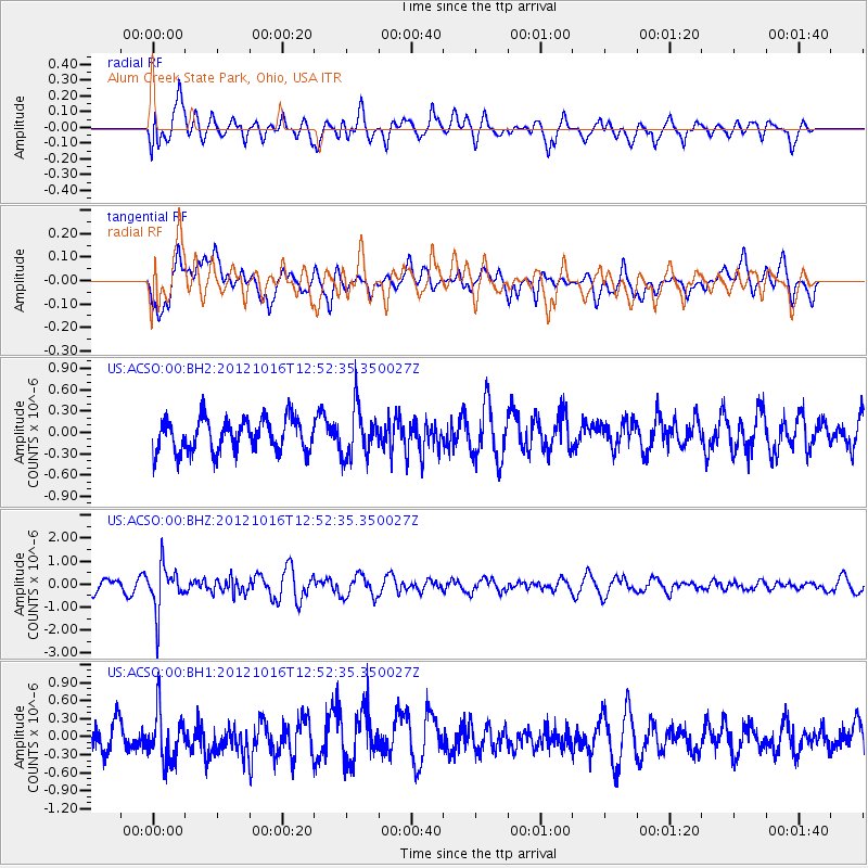
ACSO Alum Creek State Park, Ohio, USA - Earthquake Result Viewer
*The percent match for this event was below the threshold and hence no stack was calculated.
| Earthquake location: |
Kuril Islands |
| Earthquake latitude/longitude: |
49.6/156.4 |
| Earthquake time(UTC): |
2012/10/16 (290) 12:41:25 GMT |
| Earthquake Depth: |
81 km |
| Earthquake Magnitude: |
6.2 MB, 5.6 MW, 5.6 MW |
| Earthquake Catalog/Contributor: |
WHDF/NEIC |
|
| Network: |
US United States National Seismic Network |
| Station: |
ACSO Alum Creek State Park, Ohio, USA |
| Lat/Lon: |
40.23 N/82.98 W |
| Elevation: |
288 m |
|
| Distance: |
76.4 deg |
| Az: |
42.699 deg |
| Baz: |
324.821 deg |
| Ray Param: |
$rayparam |
*The percent match for this event was below the threshold and hence was not used in the summary stack. |
|
| Radial Match: |
62.4536 % |
| Radial Bump: |
400 |
| Transverse Match: |
64.30149 % |
| Transverse Bump: |
400 |
| SOD ConfigId: |
558545 |
| Insert Time: |
2013-09-17 20:54:49.789 +0000 |
| GWidth: |
2.5 |
| Max Bumps: |
400 |
| Tol: |
0.001 |
|
Signal To Noise
| Channel | StoN | STA | LTA |
| US:ACSO:00:BHZ:20121016T12:52:35.350027Z | 3.8029277 | 9.645644E-7 | 2.5363732E-7 |
| US:ACSO:00:BH1:20121016T12:52:35.350027Z | 1.2647396 | 4.180527E-7 | 3.305445E-7 |
| US:ACSO:00:BH2:20121016T12:52:35.350027Z | 1.5052818 | 3.423791E-7 | 2.2745184E-7 |
| Arrivals |
| Ps | |
| PpPs | |
| PsPs/PpSs | |


