You are here: Home > Network List > US - United States National Seismic Network Stations List
> Station AMTX Amarillo, Texas, USA > Earthquake Result Viewer
AMTX Amarillo, Texas, USA - Earthquake Result Viewer
*The percent match for this event was below the threshold and hence no stack was calculated.
| Earthquake location: |
Kuril Islands |
| Earthquake latitude/longitude: |
49.6/156.4 |
| Earthquake time(UTC): |
2012/10/16 (290) 12:41:25 GMT |
| Earthquake Depth: |
81 km |
| Earthquake Magnitude: |
6.2 MB, 5.6 MW, 5.6 MW |
| Earthquake Catalog/Contributor: |
WHDF/NEIC |
|
| Network: |
US United States National Seismic Network |
| Station: |
AMTX Amarillo, Texas, USA |
| Lat/Lon: |
34.53 N/101.41 W |
| Elevation: |
1010 m |
|
| Distance: |
71.6 deg |
| Az: |
58.272 deg |
| Baz: |
317.928 deg |
| Ray Param: |
$rayparam |
*The percent match for this event was below the threshold and hence was not used in the summary stack. |
|
| Radial Match: |
60.76556 % |
| Radial Bump: |
400 |
| Transverse Match: |
48.337513 % |
| Transverse Bump: |
400 |
| SOD ConfigId: |
558545 |
| Insert Time: |
2013-09-17 20:55:03.638 +0000 |
| GWidth: |
2.5 |
| Max Bumps: |
400 |
| Tol: |
0.001 |
|
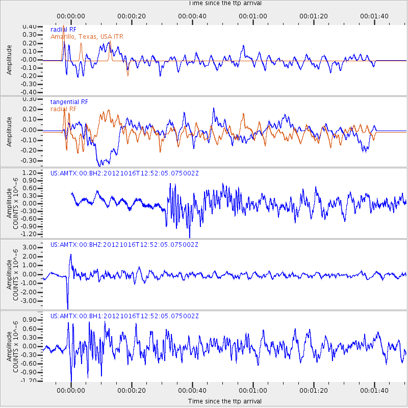
Signal To Noise
| Channel | StoN | STA | LTA |
| US:AMTX:00:BHZ:20121016T12:52:05.075002Z | 4.5921636 | 9.0463914E-7 | 1.9699628E-7 |
| US:AMTX:00:BH1:20121016T12:52:05.075002Z | 2.965356 | 4.4153307E-7 | 1.4889716E-7 |
| US:AMTX:00:BH2:20121016T12:52:05.075002Z | 3.3608844 | 4.9191596E-7 | 1.4636504E-7 |
| Arrivals |
| Ps | |
| PpPs | |
| PsPs/PpSs | |


