You are here: Home > Network List > TA - USArray Transportable Network (new EarthScope stations) Stations List
> Station C36M Paulatuk, NT, CAN > Earthquake Result Viewer
C36M Paulatuk, NT, CAN - Earthquake Result Viewer
| Earthquake location: |
Iceland |
| Earthquake latitude/longitude: |
64.7/-17.4 |
| Earthquake time(UTC): |
2014/08/28 (240) 08:13:42 GMT |
| Earthquake Depth: |
4.0 km |
| Earthquake Magnitude: |
5.4 MW, 5.0 mb, 5.0 Ms_20, 5.4 Mwb, 5.4 Mww, 5.5 Mwc |
| Earthquake Catalog/Contributor: |
ISC/ISC |
|
| Network: |
TA USArray Transportable Network (new EarthScope stations) |
| Station: |
C36M Paulatuk, NT, CAN |
| Lat/Lon: |
69.35 N/124.07 W |
| Elevation: |
10 m |
|
| Distance: |
36.8 deg |
| Az: |
325.464 deg |
| Baz: |
43.38 deg |
| Ray Param: |
0.07648098 |
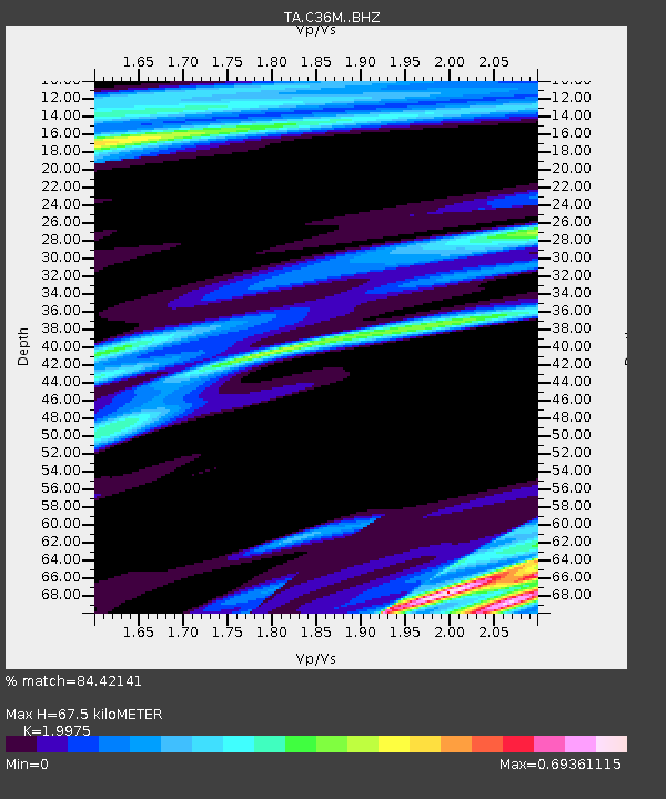
| Estimated Moho Depth: |
67.5 km |
| Estimated Crust Vp/Vs: |
2.00 |
| Assumed Crust Vp: |
6.459 km/s |
| Estimated Crust Vs: |
3.234 km/s |
| Estimated Crust Poisson's Ratio: |
0.33 |
|
| Radial Match: |
84.42141 % |
| Radial Bump: |
400 |
| Transverse Match: |
62.28211 % |
| Transverse Bump: |
400 |
| SOD ConfigId: |
3390531 |
| Insert Time: |
2019-04-13 16:29:30.535 +0000 |
| GWidth: |
2.5 |
| Max Bumps: |
400 |
| Tol: |
0.001 |
|

Signal To Noise
| Channel | StoN | STA | LTA |
| TA:C36M: :BHZ:20140828T08:20:20.498992Z | 6.9312806 | 6.7601314E-7 | 9.753077E-8 |
| TA:C36M: :BHN:20140828T08:20:20.498992Z | 1.4175549 | 1.6332359E-7 | 1.1521501E-7 |
| TA:C36M: :BHE:20140828T08:20:20.498992Z | 3.3011909 | 2.5612806E-7 | 7.758656E-8 |
| Arrivals |
| Ps | 11 SECOND |
| PpPs | 29 SECOND |
| PsPs/PpSs | 40 SECOND |


