You are here: Home > Network List > US - United States National Seismic Network Stations List
> Station KSU1 Kansas State University--Konza Prairie, Kansas, USA > Earthquake Result Viewer
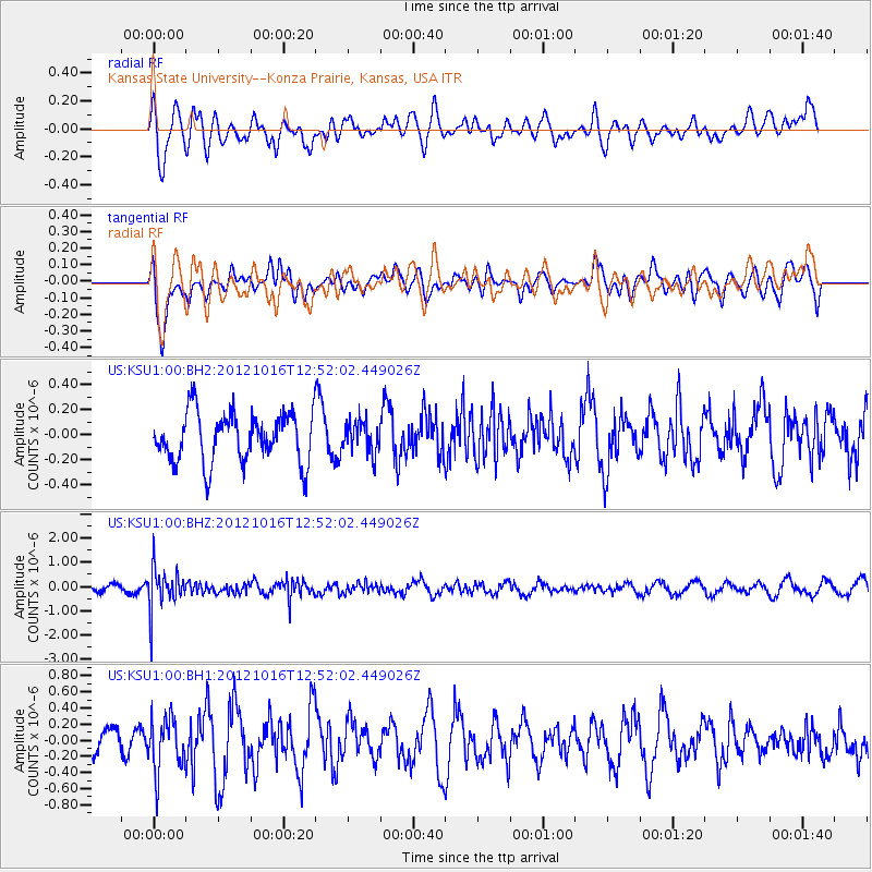
KSU1 Kansas State University--Konza Prairie, Kansas, USA - Earthquake Result Viewer
*The percent match for this event was below the threshold and hence no stack was calculated.
| Earthquake location: |
Kuril Islands |
| Earthquake latitude/longitude: |
49.6/156.4 |
| Earthquake time(UTC): |
2012/10/16 (290) 12:41:25 GMT |
| Earthquake Depth: |
81 km |
| Earthquake Magnitude: |
6.2 MB, 5.6 MW, 5.6 MW |
| Earthquake Catalog/Contributor: |
WHDF/NEIC |
|
| Network: |
US United States National Seismic Network |
| Station: |
KSU1 Kansas State University--Konza Prairie, Kansas, USA |
| Lat/Lon: |
39.10 N/96.61 W |
| Elevation: |
347 m |
|
| Distance: |
70.8 deg |
| Az: |
52.03 deg |
| Baz: |
318.78 deg |
| Ray Param: |
$rayparam |
*The percent match for this event was below the threshold and hence was not used in the summary stack. |
|
| Radial Match: |
45.75867 % |
| Radial Bump: |
400 |
| Transverse Match: |
59.357315 % |
| Transverse Bump: |
400 |
| SOD ConfigId: |
558545 |
| Insert Time: |
2013-09-17 20:56:27.725 +0000 |
| GWidth: |
2.5 |
| Max Bumps: |
400 |
| Tol: |
0.001 |
|
Signal To Noise
| Channel | StoN | STA | LTA |
| US:KSU1:00:BHZ:20121016T12:52:02.449026Z | 4.947331 | 8.2485957E-7 | 1.667282E-7 |
| US:KSU1:00:BH1:20121016T12:52:02.449026Z | 2.0945802 | 3.2771902E-7 | 1.5646047E-7 |
| US:KSU1:00:BH2:20121016T12:52:02.449026Z | 0.62703776 | 1.2354025E-7 | 1.9702202E-7 |
| Arrivals |
| Ps | |
| PpPs | |
| PsPs/PpSs | |


