You are here: Home > Network List > US - United States National Seismic Network Stations List
> Station MVCO Mesa Verde, Colorado, USA > Earthquake Result Viewer
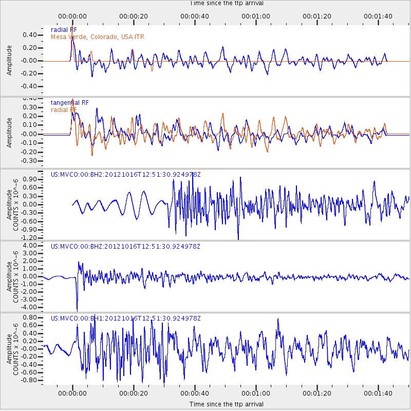
MVCO Mesa Verde, Colorado, USA - Earthquake Result Viewer
*The percent match for this event was below the threshold and hence no stack was calculated.
| Earthquake location: |
Kuril Islands |
| Earthquake latitude/longitude: |
49.6/156.4 |
| Earthquake time(UTC): |
2012/10/16 (290) 12:41:25 GMT |
| Earthquake Depth: |
81 km |
| Earthquake Magnitude: |
6.2 MB, 5.6 MW, 5.6 MW |
| Earthquake Catalog/Contributor: |
WHDF/NEIC |
|
| Network: |
US United States National Seismic Network |
| Station: |
MVCO Mesa Verde, Colorado, USA |
| Lat/Lon: |
37.21 N/108.50 W |
| Elevation: |
2170 m |
|
| Distance: |
65.7 deg |
| Az: |
60.761 deg |
| Baz: |
314.695 deg |
| Ray Param: |
$rayparam |
*The percent match for this event was below the threshold and hence was not used in the summary stack. |
|
| Radial Match: |
59.66428 % |
| Radial Bump: |
400 |
| Transverse Match: |
62.9554 % |
| Transverse Bump: |
400 |
| SOD ConfigId: |
558545 |
| Insert Time: |
2013-09-17 20:57:00.862 +0000 |
| GWidth: |
2.5 |
| Max Bumps: |
400 |
| Tol: |
0.001 |
|
Signal To Noise
| Channel | StoN | STA | LTA |
| US:MVCO:00:BHZ:20121016T12:51:30.924978Z | 7.301028 | 1.2762555E-6 | 1.7480491E-7 |
| US:MVCO:00:BH1:20121016T12:51:30.924978Z | 1.7024623 | 3.2537838E-7 | 1.9112223E-7 |
| US:MVCO:00:BH2:20121016T12:51:30.924978Z | 1.6840523 | 3.7750604E-7 | 2.2416526E-7 |
| Arrivals |
| Ps | |
| PpPs | |
| PsPs/PpSs | |


