You are here: Home > Network List > US - United States National Seismic Network Stations List
> Station NATX Nacogdoches, Texas, USA > Earthquake Result Viewer
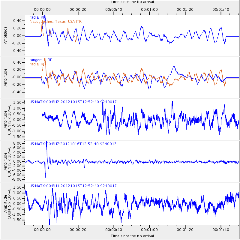
NATX Nacogdoches, Texas, USA - Earthquake Result Viewer
*The percent match for this event was below the threshold and hence no stack was calculated.
| Earthquake location: |
Kuril Islands |
| Earthquake latitude/longitude: |
49.6/156.4 |
| Earthquake time(UTC): |
2012/10/16 (290) 12:41:25 GMT |
| Earthquake Depth: |
81 km |
| Earthquake Magnitude: |
6.2 MB, 5.6 MW, 5.6 MW |
| Earthquake Catalog/Contributor: |
WHDF/NEIC |
|
| Network: |
US United States National Seismic Network |
| Station: |
NATX Nacogdoches, Texas, USA |
| Lat/Lon: |
31.76 N/94.66 W |
| Elevation: |
156 m |
|
| Distance: |
77.4 deg |
| Az: |
55.674 deg |
| Baz: |
320.909 deg |
| Ray Param: |
$rayparam |
*The percent match for this event was below the threshold and hence was not used in the summary stack. |
|
| Radial Match: |
53.030533 % |
| Radial Bump: |
400 |
| Transverse Match: |
44.653847 % |
| Transverse Bump: |
400 |
| SOD ConfigId: |
558545 |
| Insert Time: |
2013-09-17 20:57:07.980 +0000 |
| GWidth: |
2.5 |
| Max Bumps: |
400 |
| Tol: |
0.001 |
|
Signal To Noise
| Channel | StoN | STA | LTA |
| US:NATX:00:BHZ:20121016T12:52:40.924001Z | 10.901658 | 2.8676534E-6 | 2.6304747E-7 |
| US:NATX:00:BH1:20121016T12:52:40.924001Z | 1.6496979 | 6.9487413E-7 | 4.2121295E-7 |
| US:NATX:00:BH2:20121016T12:52:40.924001Z | 1.6857525 | 6.3170756E-7 | 3.7473328E-7 |
| Arrivals |
| Ps | |
| PpPs | |
| PsPs/PpSs | |


