You are here: Home > Network List > US - United States National Seismic Network Stations List
> Station OGNE Ogallala, Nebraska, USA > Earthquake Result Viewer
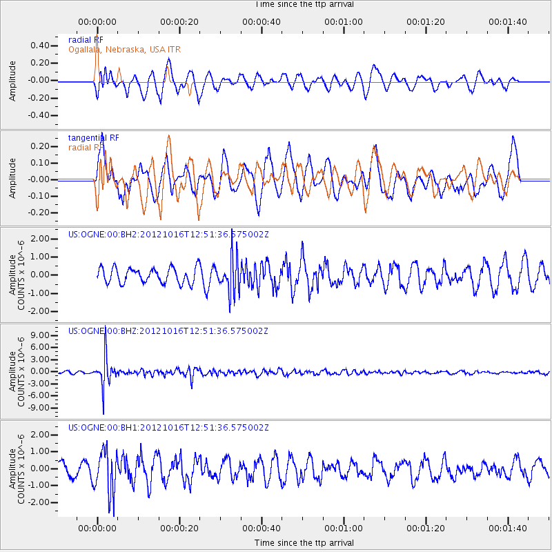
OGNE Ogallala, Nebraska, USA - Earthquake Result Viewer
*The percent match for this event was below the threshold and hence no stack was calculated.
| Earthquake location: |
Kuril Islands |
| Earthquake latitude/longitude: |
49.6/156.4 |
| Earthquake time(UTC): |
2012/10/16 (290) 12:41:25 GMT |
| Earthquake Depth: |
81 km |
| Earthquake Magnitude: |
6.2 MB, 5.6 MW, 5.6 MW |
| Earthquake Catalog/Contributor: |
WHDF/NEIC |
|
| Network: |
US United States National Seismic Network |
| Station: |
OGNE Ogallala, Nebraska, USA |
| Lat/Lon: |
40.95 N/102.03 W |
| Elevation: |
0.0 m |
|
| Distance: |
66.6 deg |
| Az: |
53.983 deg |
| Baz: |
316.015 deg |
| Ray Param: |
$rayparam |
*The percent match for this event was below the threshold and hence was not used in the summary stack. |
|
| Radial Match: |
60.9329 % |
| Radial Bump: |
400 |
| Transverse Match: |
46.297264 % |
| Transverse Bump: |
400 |
| SOD ConfigId: |
558545 |
| Insert Time: |
2013-09-17 20:57:19.596 +0000 |
| GWidth: |
2.5 |
| Max Bumps: |
400 |
| Tol: |
0.001 |
|
Signal To Noise
| Channel | StoN | STA | LTA |
| US:OGNE:00:BHZ:20121016T12:51:36.575002Z | 11.002881 | 3.6563258E-6 | 3.3230623E-7 |
| US:OGNE:00:BH1:20121016T12:51:36.575002Z | 2.776678 | 1.273609E-6 | 4.586808E-7 |
| US:OGNE:00:BH2:20121016T12:51:36.575002Z | 2.3004029 | 9.515437E-7 | 4.136422E-7 |
| Arrivals |
| Ps | |
| PpPs | |
| PsPs/PpSs | |


