You are here: Home > Network List > US - United States National Seismic Network Stations List
> Station WUAZ Wupatki, Arizona, USA > Earthquake Result Viewer
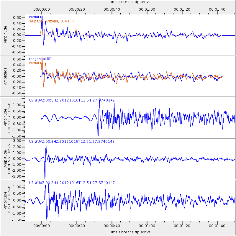
WUAZ Wupatki, Arizona, USA - Earthquake Result Viewer
*The percent match for this event was below the threshold and hence no stack was calculated.
| Earthquake location: |
Kuril Islands |
| Earthquake latitude/longitude: |
49.6/156.4 |
| Earthquake time(UTC): |
2012/10/16 (290) 12:41:25 GMT |
| Earthquake Depth: |
81 km |
| Earthquake Magnitude: |
6.2 MB, 5.6 MW, 5.6 MW |
| Earthquake Catalog/Contributor: |
WHDF/NEIC |
|
| Network: |
US United States National Seismic Network |
| Station: |
WUAZ Wupatki, Arizona, USA |
| Lat/Lon: |
35.52 N/111.37 W |
| Elevation: |
1592 m |
|
| Distance: |
65.2 deg |
| Az: |
63.873 deg |
| Baz: |
314.29 deg |
| Ray Param: |
$rayparam |
*The percent match for this event was below the threshold and hence was not used in the summary stack. |
|
| Radial Match: |
73.733 % |
| Radial Bump: |
400 |
| Transverse Match: |
70.62017 % |
| Transverse Bump: |
400 |
| SOD ConfigId: |
558545 |
| Insert Time: |
2013-09-17 20:58:05.181 +0000 |
| GWidth: |
2.5 |
| Max Bumps: |
400 |
| Tol: |
0.001 |
|
Signal To Noise
| Channel | StoN | STA | LTA |
| US:WUAZ:00:BHZ:20121016T12:51:27.874014Z | 6.9463296 | 1.0716817E-6 | 1.5428029E-7 |
| US:WUAZ:00:BH1:20121016T12:51:27.874014Z | 4.7917423 | 6.527721E-7 | 1.3622854E-7 |
| US:WUAZ:00:BH2:20121016T12:51:27.874014Z | 4.788895 | 6.127594E-7 | 1.2795424E-7 |
| Arrivals |
| Ps | |
| PpPs | |
| PsPs/PpSs | |


