You are here: Home > Network List > II - Global Seismograph Network (GSN - IRIS/IDA) Stations List
> Station KAPI Kappang, Sulawesi, Indonesia > Earthquake Result Viewer
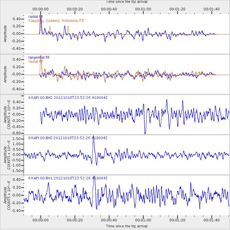
KAPI Kappang, Sulawesi, Indonesia - Earthquake Result Viewer
*The percent match for this event was below the threshold and hence no stack was calculated.
| Earthquake location: |
North Island, New Zealand |
| Earthquake latitude/longitude: |
-38.6/176.2 |
| Earthquake time(UTC): |
2012/10/16 (290) 23:42:55 GMT |
| Earthquake Depth: |
110 km |
| Earthquake Magnitude: |
5.6 MW, 5.2 MB, 5.7 MW |
| Earthquake Catalog/Contributor: |
WHDF/NEIC |
|
| Network: |
II Global Seismograph Network (GSN - IRIS/IDA) |
| Station: |
KAPI Kappang, Sulawesi, Indonesia |
| Lat/Lon: |
5.01 S/119.75 E |
| Elevation: |
300 m |
|
| Distance: |
61.0 deg |
| Az: |
288.314 deg |
| Baz: |
131.73 deg |
| Ray Param: |
$rayparam |
*The percent match for this event was below the threshold and hence was not used in the summary stack. |
|
| Radial Match: |
69.05793 % |
| Radial Bump: |
400 |
| Transverse Match: |
57.988586 % |
| Transverse Bump: |
400 |
| SOD ConfigId: |
558545 |
| Insert Time: |
2013-09-17 20:58:44.304 +0000 |
| GWidth: |
2.5 |
| Max Bumps: |
400 |
| Tol: |
0.001 |
|
Signal To Noise
| Channel | StoN | STA | LTA |
| II:KAPI:00:BHZ:20121016T23:52:26.419004Z | 2.1170092 | 2.7863206E-7 | 1.316159E-7 |
| II:KAPI:00:BH1:20121016T23:52:26.419004Z | 1.1737345 | 1.3962017E-7 | 1.18953785E-7 |
| II:KAPI:00:BH2:20121016T23:52:26.419004Z | 1.53842 | 1.5278394E-7 | 9.9312246E-8 |
| Arrivals |
| Ps | |
| PpPs | |
| PsPs/PpSs | |


