You are here: Home > Network List > IU - Global Seismograph Network (GSN - IRIS/USGS) Stations List
> Station JOHN Johnston Island, USA > Earthquake Result Viewer
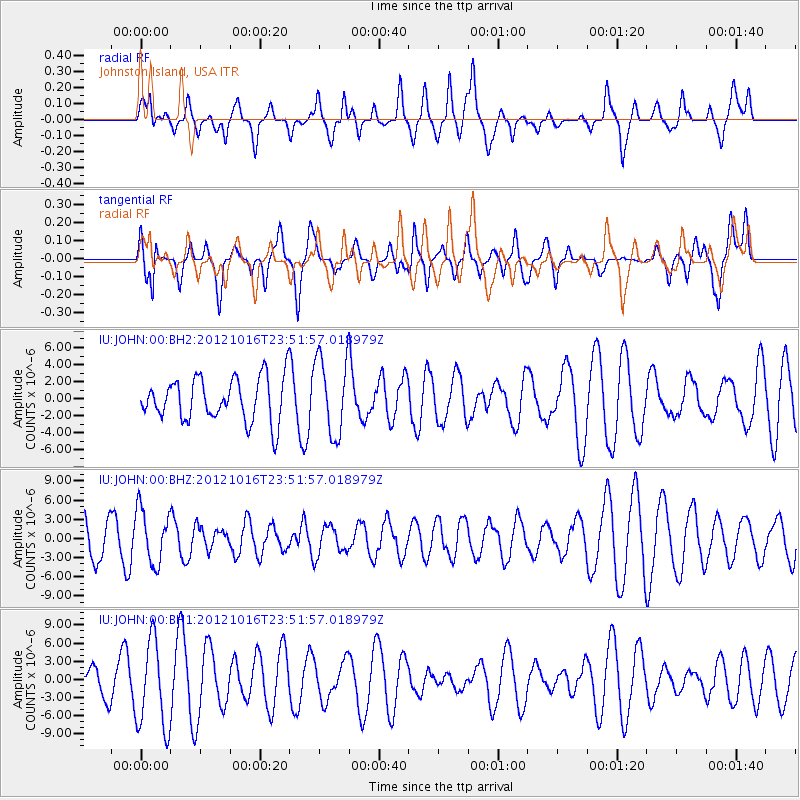
JOHN Johnston Island, USA - Earthquake Result Viewer
*The percent match for this event was below the threshold and hence no stack was calculated.
| Earthquake location: |
North Island, New Zealand |
| Earthquake latitude/longitude: |
-38.6/176.2 |
| Earthquake time(UTC): |
2012/10/16 (290) 23:42:55 GMT |
| Earthquake Depth: |
110 km |
| Earthquake Magnitude: |
5.6 MW, 5.2 MB, 5.7 MW |
| Earthquake Catalog/Contributor: |
WHDF/NEIC |
|
| Network: |
IU Global Seismograph Network (GSN - IRIS/USGS) |
| Station: |
JOHN Johnston Island, USA |
| Lat/Lon: |
16.73 N/169.53 W |
| Elevation: |
2.0 m |
|
| Distance: |
56.7 deg |
| Az: |
16.456 deg |
| Baz: |
193.387 deg |
| Ray Param: |
$rayparam |
*The percent match for this event was below the threshold and hence was not used in the summary stack. |
|
| Radial Match: |
41.01513 % |
| Radial Bump: |
400 |
| Transverse Match: |
42.770252 % |
| Transverse Bump: |
400 |
| SOD ConfigId: |
558545 |
| Insert Time: |
2013-09-17 20:59:42.643 +0000 |
| GWidth: |
2.5 |
| Max Bumps: |
400 |
| Tol: |
0.001 |
|
Signal To Noise
| Channel | StoN | STA | LTA |
| IU:JOHN:00:BHZ:20121016T23:51:57.018979Z | 0.8866639 | 4.2385195E-6 | 4.7803E-6 |
| IU:JOHN:00:BH1:20121016T23:51:57.018979Z | 2.895436 | 7.327965E-6 | 2.5308673E-6 |
| IU:JOHN:00:BH2:20121016T23:51:57.018979Z | 1.8041945 | 4.5573993E-6 | 2.5260022E-6 |
| Arrivals |
| Ps | |
| PpPs | |
| PsPs/PpSs | |


