You are here: Home > Network List > TA - USArray Transportable Network (new EarthScope stations) Stations List
> Station HDA Harding Lake, AK, USA > Earthquake Result Viewer
HDA Harding Lake, AK, USA - Earthquake Result Viewer
| Earthquake location: |
Iceland |
| Earthquake latitude/longitude: |
64.7/-17.4 |
| Earthquake time(UTC): |
2014/08/28 (240) 08:13:42 GMT |
| Earthquake Depth: |
4.0 km |
| Earthquake Magnitude: |
5.4 MW, 5.0 mb, 5.0 Ms_20, 5.4 Mwb, 5.4 Mww, 5.5 Mwc |
| Earthquake Catalog/Contributor: |
ISC/ISC |
|
| Network: |
TA USArray Transportable Network (new EarthScope stations) |
| Station: |
HDA Harding Lake, AK, USA |
| Lat/Lon: |
64.41 N/146.95 W |
| Elevation: |
437 m |
|
| Distance: |
46.0 deg |
| Az: |
332.269 deg |
| Baz: |
27.42 deg |
| Ray Param: |
0.07091913 |
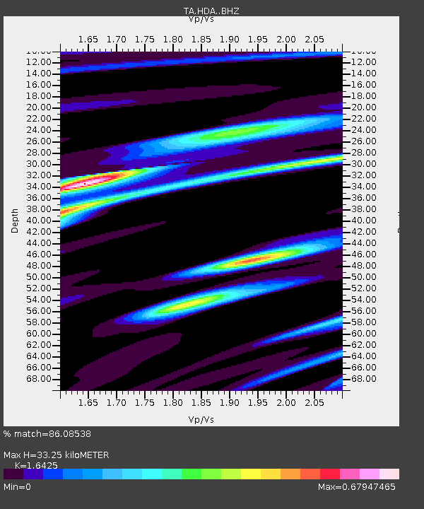
| Estimated Moho Depth: |
33.25 km |
| Estimated Crust Vp/Vs: |
1.64 |
| Assumed Crust Vp: |
6.566 km/s |
| Estimated Crust Vs: |
3.998 km/s |
| Estimated Crust Poisson's Ratio: |
0.21 |
|
| Radial Match: |
86.08538 % |
| Radial Bump: |
270 |
| Transverse Match: |
61.89214 % |
| Transverse Bump: |
400 |
| SOD ConfigId: |
3390531 |
| Insert Time: |
2019-04-13 16:29:50.475 +0000 |
| GWidth: |
2.5 |
| Max Bumps: |
400 |
| Tol: |
0.001 |
|

Signal To Noise
| Channel | StoN | STA | LTA |
| TA:HDA: :BHZ:20140828T08:21:35.799987Z | 4.6238546 | 2.8242246E-7 | 6.107944E-8 |
| TA:HDA: :BHN:20140828T08:21:35.799987Z | 1.7801901 | 1.6894283E-7 | 9.4901566E-8 |
| TA:HDA: :BHE:20140828T08:21:35.799987Z | 1.7244059 | 1.7010848E-7 | 9.864759E-8 |
| Arrivals |
| Ps | 3.5 SECOND |
| PpPs | 12 SECOND |
| PsPs/PpSs | 16 SECOND |


