You are here: Home > Network List > US - United States National Seismic Network Stations List
> Station LKWY Lake (Yellowstone--Lake), Wyoming, USA > Earthquake Result Viewer
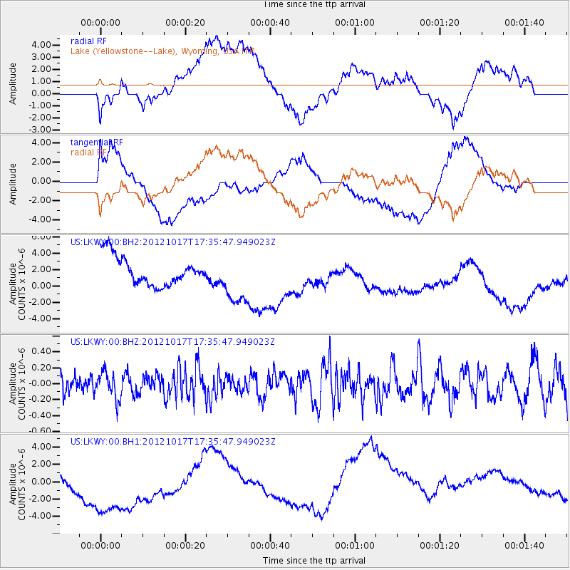
LKWY Lake (Yellowstone--Lake), Wyoming, USA - Earthquake Result Viewer
*The percent match for this event was below the threshold and hence no stack was calculated.
| Earthquake location: |
Tonga Islands |
| Earthquake latitude/longitude: |
-19.0/-174.2 |
| Earthquake time(UTC): |
2012/10/17 (291) 17:23:42 GMT |
| Earthquake Depth: |
35 km |
| Earthquake Magnitude: |
5.5 MB, 5.0 MS, 5.4 MW |
| Earthquake Catalog/Contributor: |
WHDF/NEIC |
|
| Network: |
US United States National Seismic Network |
| Station: |
LKWY Lake (Yellowstone--Lake), Wyoming, USA |
| Lat/Lon: |
44.57 N/110.40 W |
| Elevation: |
2424 m |
|
| Distance: |
85.9 deg |
| Az: |
40.013 deg |
| Baz: |
238.306 deg |
| Ray Param: |
$rayparam |
*The percent match for this event was below the threshold and hence was not used in the summary stack. |
|
| Radial Match: |
26.246984 % |
| Radial Bump: |
400 |
| Transverse Match: |
52.90045 % |
| Transverse Bump: |
400 |
| SOD ConfigId: |
558545 |
| Insert Time: |
2013-09-17 21:05:59.363 +0000 |
| GWidth: |
2.5 |
| Max Bumps: |
400 |
| Tol: |
0.001 |
|
Signal To Noise
| Channel | StoN | STA | LTA |
| US:LKWY:00:BHZ:20121017T17:35:47.949023Z | 0.77367187 | 1.7404552E-7 | 2.2496039E-7 |
| US:LKWY:00:BH1:20121017T17:35:47.949023Z | 2.1264174 | 6.821888E-6 | 3.2081605E-6 |
| US:LKWY:00:BH2:20121017T17:35:47.949023Z | 1.8987836 | 3.258578E-6 | 1.7161399E-6 |
| Arrivals |
| Ps | |
| PpPs | |
| PsPs/PpSs | |


