You are here: Home > Network List > II - Global Seismograph Network (GSN - IRIS/IDA) Stations List
> Station WRAB Tennant Creek, NT, Australia > Earthquake Result Viewer
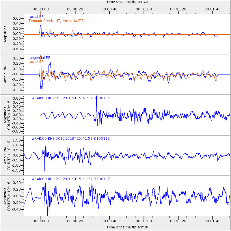
WRAB Tennant Creek, NT, Australia - Earthquake Result Viewer
*The percent match for this event was below the threshold and hence no stack was calculated.
| Earthquake location: |
Kermadec Islands Region |
| Earthquake latitude/longitude: |
-30.8/-176.8 |
| Earthquake time(UTC): |
2012/10/19 (293) 15:34:09 GMT |
| Earthquake Depth: |
35 km |
| Earthquake Magnitude: |
5.5 MB |
| Earthquake Catalog/Contributor: |
NEIC PDE/NEIC PDE-W |
|
| Network: |
II Global Seismograph Network (GSN - IRIS/IDA) |
| Station: |
WRAB Tennant Creek, NT, Australia |
| Lat/Lon: |
19.93 S/134.36 E |
| Elevation: |
366 m |
|
| Distance: |
45.1 deg |
| Az: |
271.939 deg |
| Baz: |
113.938 deg |
| Ray Param: |
$rayparam |
*The percent match for this event was below the threshold and hence was not used in the summary stack. |
|
| Radial Match: |
62.462475 % |
| Radial Bump: |
400 |
| Transverse Match: |
69.07231 % |
| Transverse Bump: |
400 |
| SOD ConfigId: |
558545 |
| Insert Time: |
2013-09-17 21:11:32.363 +0000 |
| GWidth: |
2.5 |
| Max Bumps: |
400 |
| Tol: |
0.001 |
|
Signal To Noise
| Channel | StoN | STA | LTA |
| II:WRAB:00:BHZ:20121019T15:41:52.319011Z | 2.8914254 | 5.280378E-7 | 1.8262196E-7 |
| II:WRAB:00:BH1:20121019T15:41:52.319011Z | 1.6752706 | 2.323378E-7 | 1.3868673E-7 |
| II:WRAB:00:BH2:20121019T15:41:52.319011Z | 2.8241405 | 2.6550936E-7 | 9.401422E-8 |
| Arrivals |
| Ps | |
| PpPs | |
| PsPs/PpSs | |


