You are here: Home > Network List > IU - Global Seismograph Network (GSN - IRIS/USGS) Stations List
> Station GUMO Guam, Mariana Islands > Earthquake Result Viewer
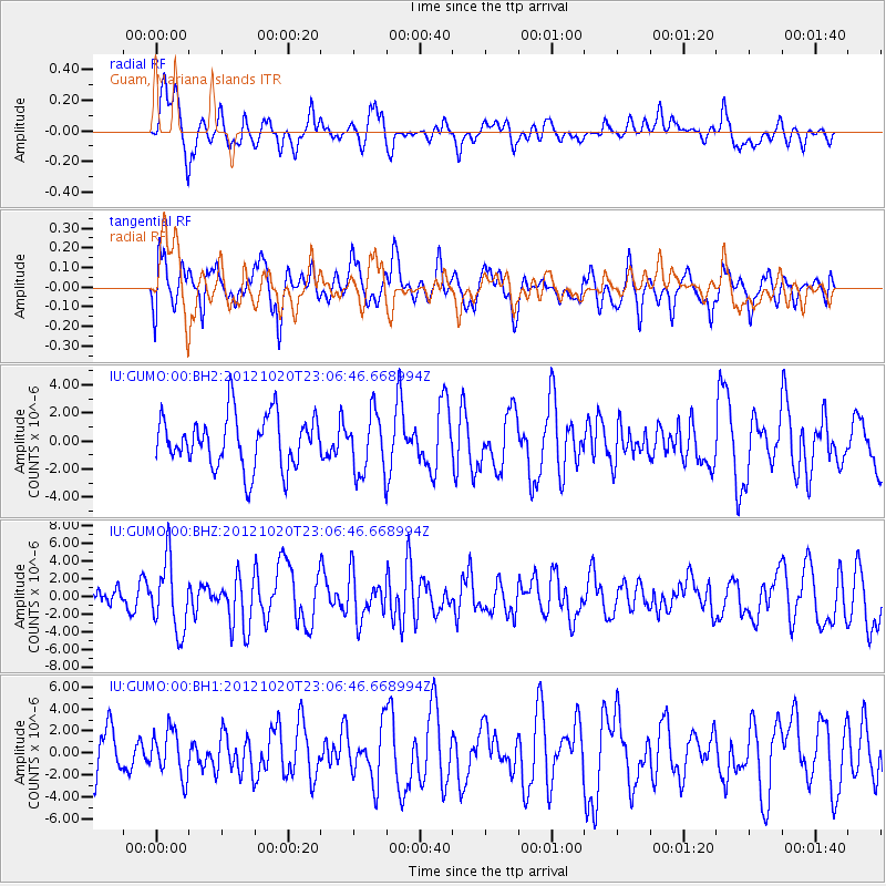
GUMO Guam, Mariana Islands - Earthquake Result Viewer
*The percent match for this event was below the threshold and hence no stack was calculated.
| Earthquake location: |
Vanuatu Islands |
| Earthquake latitude/longitude: |
-13.6/166.6 |
| Earthquake time(UTC): |
2012/10/20 (294) 23:00:32 GMT |
| Earthquake Depth: |
36 km |
| Earthquake Magnitude: |
5.9 MB, 6.1 MS, 6.2 MW, 6.2 MW |
| Earthquake Catalog/Contributor: |
WHDF/NEIC |
|
| Network: |
IU Global Seismograph Network (GSN - IRIS/USGS) |
| Station: |
GUMO Guam, Mariana Islands |
| Lat/Lon: |
13.59 N/144.87 E |
| Elevation: |
170 m |
|
| Distance: |
34.5 deg |
| Az: |
320.588 deg |
| Baz: |
140.581 deg |
| Ray Param: |
$rayparam |
*The percent match for this event was below the threshold and hence was not used in the summary stack. |
|
| Radial Match: |
62.034496 % |
| Radial Bump: |
358 |
| Transverse Match: |
64.554726 % |
| Transverse Bump: |
400 |
| SOD ConfigId: |
558545 |
| Insert Time: |
2013-09-17 21:15:09.675 +0000 |
| GWidth: |
2.5 |
| Max Bumps: |
400 |
| Tol: |
0.001 |
|
Signal To Noise
| Channel | StoN | STA | LTA |
| IU:GUMO:00:BHZ:20121020T23:06:46.668994Z | 3.3868475 | 3.930988E-6 | 1.1606628E-6 |
| IU:GUMO:00:BH1:20121020T23:06:46.668994Z | 0.9318778 | 2.070273E-6 | 2.2216143E-6 |
| IU:GUMO:00:BH2:20121020T23:06:46.668994Z | 1.1644528 | 2.1606327E-6 | 1.8554919E-6 |
| Arrivals |
| Ps | |
| PpPs | |
| PsPs/PpSs | |


