You are here: Home > Network List > US - United States National Seismic Network Stations List
> Station OGNE Ogallala, Nebraska, USA > Earthquake Result Viewer
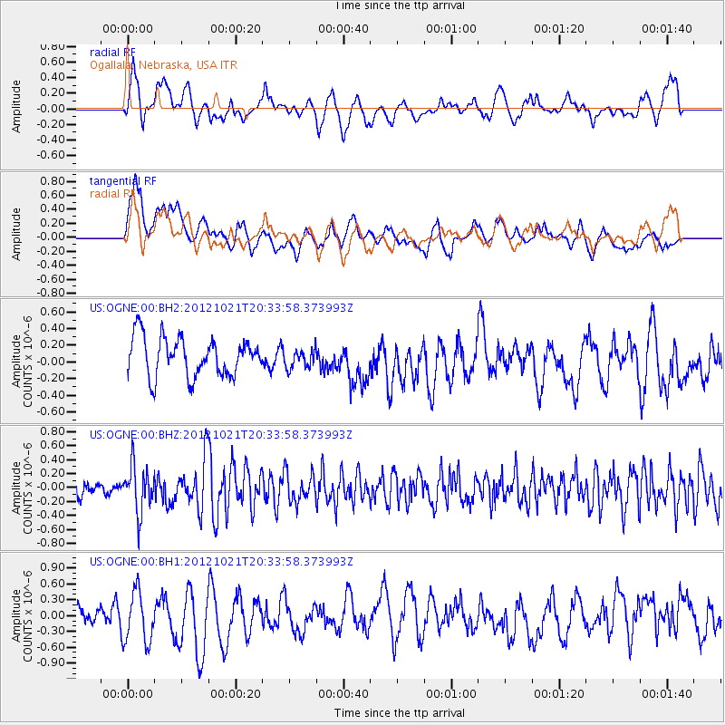
OGNE Ogallala, Nebraska, USA - Earthquake Result Viewer
*The percent match for this event was below the threshold and hence no stack was calculated.
| Earthquake location: |
Off Coast Of Central America |
| Earthquake latitude/longitude: |
12.6/-88.3 |
| Earthquake time(UTC): |
2012/10/21 (295) 20:28:17 GMT |
| Earthquake Depth: |
36 km |
| Earthquake Magnitude: |
5.5 MW, 5.5 MB |
| Earthquake Catalog/Contributor: |
NEIC PDE/NEIC PDE-W |
|
| Network: |
US United States National Seismic Network |
| Station: |
OGNE Ogallala, Nebraska, USA |
| Lat/Lon: |
40.95 N/102.03 W |
| Elevation: |
0.0 m |
|
| Distance: |
30.7 deg |
| Az: |
339.446 deg |
| Baz: |
153.095 deg |
| Ray Param: |
$rayparam |
*The percent match for this event was below the threshold and hence was not used in the summary stack. |
|
| Radial Match: |
56.726463 % |
| Radial Bump: |
400 |
| Transverse Match: |
62.160515 % |
| Transverse Bump: |
400 |
| SOD ConfigId: |
558545 |
| Insert Time: |
2013-09-17 21:25:40.906 +0000 |
| GWidth: |
2.5 |
| Max Bumps: |
400 |
| Tol: |
0.001 |
|
Signal To Noise
| Channel | StoN | STA | LTA |
| US:OGNE:00:BHZ:20121021T20:33:58.373993Z | 2.0299926 | 3.3104408E-7 | 1.630765E-7 |
| US:OGNE:00:BH1:20121021T20:33:58.373993Z | 2.382246 | 4.9575584E-7 | 2.0810438E-7 |
| US:OGNE:00:BH2:20121021T20:33:58.373993Z | 0.4975617 | 1.14670584E-7 | 2.3046506E-7 |
| Arrivals |
| Ps | |
| PpPs | |
| PsPs/PpSs | |


