You are here: Home > Network List > US - United States National Seismic Network Stations List
> Station BMO Blue Mountains Array (Baker), Oregon, USA > Earthquake Result Viewer
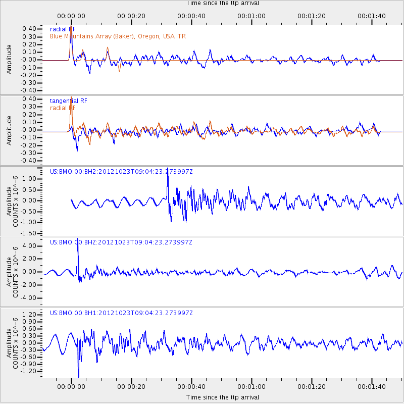
BMO Blue Mountains Array (Baker), Oregon, USA - Earthquake Result Viewer
*The percent match for this event was below the threshold and hence no stack was calculated.
| Earthquake location: |
Southeast Of Honshu, Japan |
| Earthquake latitude/longitude: |
29.1/139.3 |
| Earthquake time(UTC): |
2012/10/23 (297) 08:53:38 GMT |
| Earthquake Depth: |
436 km |
| Earthquake Magnitude: |
6.0 MB, 5.9 MW, 6.0 MW |
| Earthquake Catalog/Contributor: |
WHDF/NEIC |
|
| Network: |
US United States National Seismic Network |
| Station: |
BMO Blue Mountains Array (Baker), Oregon, USA |
| Lat/Lon: |
44.85 N/117.31 W |
| Elevation: |
1189 m |
|
| Distance: |
78.8 deg |
| Az: |
44.859 deg |
| Baz: |
299.754 deg |
| Ray Param: |
$rayparam |
*The percent match for this event was below the threshold and hence was not used in the summary stack. |
|
| Radial Match: |
50.165215 % |
| Radial Bump: |
400 |
| Transverse Match: |
35.136307 % |
| Transverse Bump: |
400 |
| SOD ConfigId: |
558545 |
| Insert Time: |
2013-09-17 21:28:31.187 +0000 |
| GWidth: |
2.5 |
| Max Bumps: |
400 |
| Tol: |
0.001 |
|
Signal To Noise
| Channel | StoN | STA | LTA |
| US:BMO:00:BHZ:20121023T09:04:23.273997Z | 8.071525 | 1.3040788E-6 | 1.6156537E-7 |
| US:BMO:00:BH1:20121023T09:04:23.273997Z | 3.2274945 | 4.4955772E-7 | 1.3929001E-7 |
| US:BMO:00:BH2:20121023T09:04:23.273997Z | 3.7522645 | 4.593307E-7 | 1.2241426E-7 |
| Arrivals |
| Ps | |
| PpPs | |
| PsPs/PpSs | |


