You are here: Home > Network List > US - United States National Seismic Network Stations List
> Station CBKS Cedar Bluff, Kansas, USA > Earthquake Result Viewer
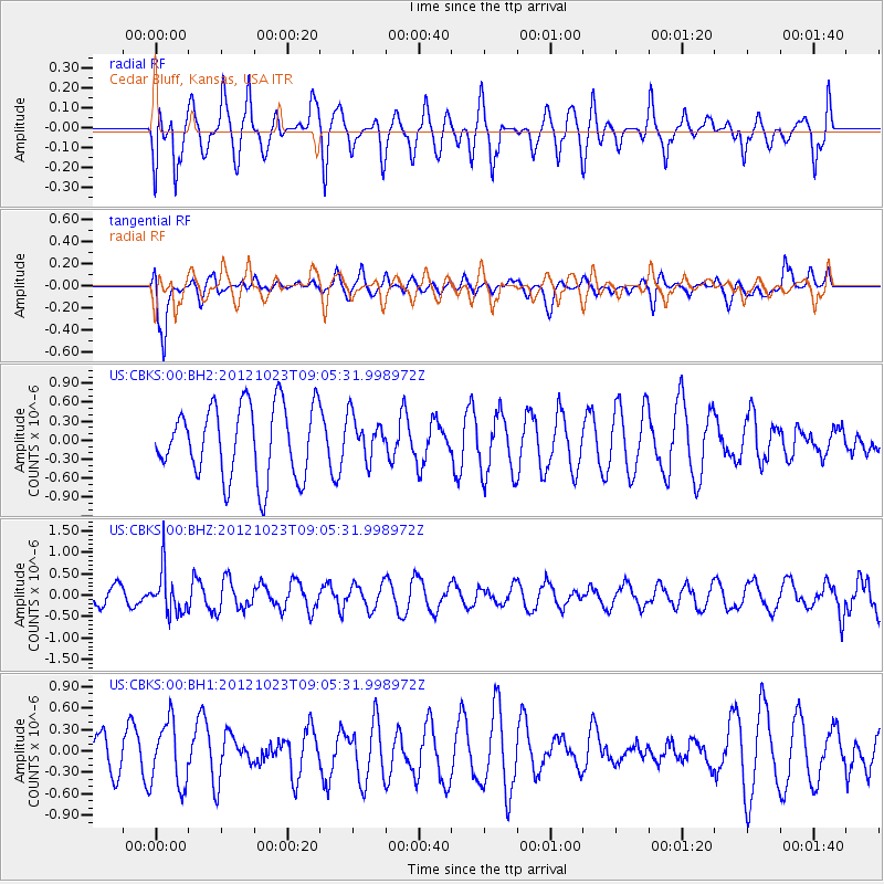
CBKS Cedar Bluff, Kansas, USA - Earthquake Result Viewer
*The percent match for this event was below the threshold and hence no stack was calculated.
| Earthquake location: |
Southeast Of Honshu, Japan |
| Earthquake latitude/longitude: |
29.1/139.3 |
| Earthquake time(UTC): |
2012/10/23 (297) 08:53:38 GMT |
| Earthquake Depth: |
436 km |
| Earthquake Magnitude: |
6.0 MB, 5.9 MW, 6.0 MW |
| Earthquake Catalog/Contributor: |
WHDF/NEIC |
|
| Network: |
US United States National Seismic Network |
| Station: |
CBKS Cedar Bluff, Kansas, USA |
| Lat/Lon: |
38.81 N/99.74 W |
| Elevation: |
677 m |
|
| Distance: |
92.9 deg |
| Az: |
42.1 deg |
| Baz: |
311.293 deg |
| Ray Param: |
$rayparam |
*The percent match for this event was below the threshold and hence was not used in the summary stack. |
|
| Radial Match: |
46.83929 % |
| Radial Bump: |
400 |
| Transverse Match: |
81.6628 % |
| Transverse Bump: |
400 |
| SOD ConfigId: |
558545 |
| Insert Time: |
2013-09-17 21:28:44.207 +0000 |
| GWidth: |
2.5 |
| Max Bumps: |
400 |
| Tol: |
0.001 |
|
Signal To Noise
| Channel | StoN | STA | LTA |
| US:CBKS:00:BHZ:20121023T09:05:31.998972Z | 2.0691621 | 5.036653E-7 | 2.4341512E-7 |
| US:CBKS:00:BH1:20121023T09:05:31.998972Z | 1.786676 | 4.4987553E-7 | 2.5179466E-7 |
| US:CBKS:00:BH2:20121023T09:05:31.998972Z | 0.5885557 | 3.3480805E-7 | 5.688638E-7 |
| Arrivals |
| Ps | |
| PpPs | |
| PsPs/PpSs | |


