You are here: Home > Network List > II - Global Seismograph Network (GSN - IRIS/IDA) Stations List
> Station WRAB Tennant Creek, NT, Australia > Earthquake Result Viewer
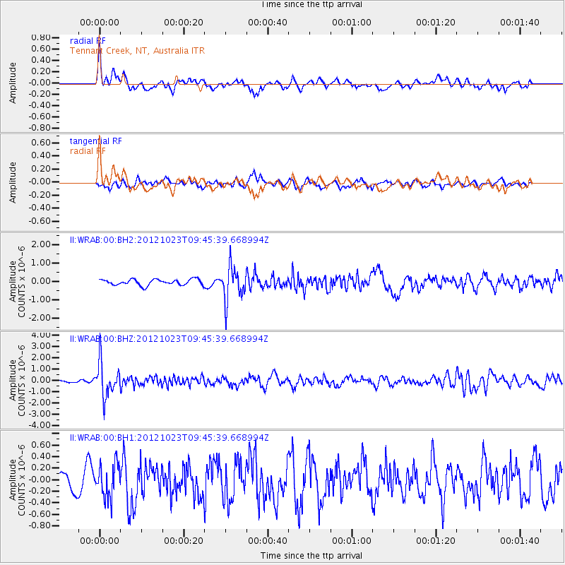
WRAB Tennant Creek, NT, Australia - Earthquake Result Viewer
*The percent match for this event was below the threshold and hence no stack was calculated.
| Earthquake location: |
Southeast Of Loyalty Islands |
| Earthquake latitude/longitude: |
-22.3/171.7 |
| Earthquake time(UTC): |
2012/10/23 (297) 09:39:30 GMT |
| Earthquake Depth: |
123 km |
| Earthquake Magnitude: |
5.9 MB, 5.8 MW, 5.9 MW |
| Earthquake Catalog/Contributor: |
WHDF/NEIC |
|
| Network: |
II Global Seismograph Network (GSN - IRIS/IDA) |
| Station: |
WRAB Tennant Creek, NT, Australia |
| Lat/Lon: |
19.93 S/134.36 E |
| Elevation: |
366 m |
|
| Distance: |
34.8 deg |
| Az: |
266.844 deg |
| Baz: |
100.648 deg |
| Ray Param: |
$rayparam |
*The percent match for this event was below the threshold and hence was not used in the summary stack. |
|
| Radial Match: |
68.15841 % |
| Radial Bump: |
400 |
| Transverse Match: |
52.86291 % |
| Transverse Bump: |
400 |
| SOD ConfigId: |
558545 |
| Insert Time: |
2013-09-17 21:32:15.384 +0000 |
| GWidth: |
2.5 |
| Max Bumps: |
400 |
| Tol: |
0.001 |
|
Signal To Noise
| Channel | StoN | STA | LTA |
| II:WRAB:00:BHZ:20121023T09:45:39.668994Z | 8.207463 | 1.5496862E-6 | 1.8881428E-7 |
| II:WRAB:00:BH1:20121023T09:45:39.668994Z | 2.4743028 | 2.874374E-7 | 1.1616905E-7 |
| II:WRAB:00:BH2:20121023T09:45:39.668994Z | 5.8612275 | 9.336715E-7 | 1.5929625E-7 |
| Arrivals |
| Ps | |
| PpPs | |
| PsPs/PpSs | |


